Difference between revisions of "ArcTUFLOW Configure TUFLOW"
Jump to navigation
Jump to search
Chris Huxley (talk | contribs) |
m (Par moved page Configure TUFLOW to ArcTUFLOW Configure TUFLOW: Added AcrTUFLOW to avoid confusion.) |
||
| (One intermediate revision by one other user not shown) | |||
| Line 1: | Line 1: | ||
| − | The first item “Configure TUFLOW” creates a configuration file for all of the arcTUFLOW tools based on the map document. The steps for running the configuration tool are outlined below: | + | The first item, “Configure TUFLOW”, creates a configuration file for all of the arcTUFLOW tools based on the map document. The steps for running the configuration tool are outlined below: |
* Open or save a map document before running). | * Open or save a map document before running). | ||
* Select a TUFLOW folder for your model. This should be the folder that contains the entire TUFLOW model folder structure. For example, if your TUFLOW folder is "D:\projects\Example\TUFLOW", the folder set here should be “D:\projects\Example\”. All of the following tools will use this location. | * Select a TUFLOW folder for your model. This should be the folder that contains the entire TUFLOW model folder structure. For example, if your TUFLOW folder is "D:\projects\Example\TUFLOW", the folder set here should be “D:\projects\Example\”. All of the following tools will use this location. | ||
Latest revision as of 11:21, 4 June 2015
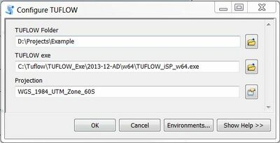
The first item, “Configure TUFLOW”, creates a configuration file for all of the arcTUFLOW tools based on the map document. The steps for running the configuration tool are outlined below:
- Open or save a map document before running).
- Select a TUFLOW folder for your model. This should be the folder that contains the entire TUFLOW model folder structure. For example, if your TUFLOW folder is "D:\projects\Example\TUFLOW", the folder set here should be “D:\projects\Example\”. All of the following tools will use this location.
- Enter the file path to the TUFLOW executable
- Select the projection for the TUFLOW model
| Up |
|---|
