FM Tute M02 QGIS Define Roughness: Difference between revisions
Jump to navigation
Jump to search
Content deleted Content added
Tuflowduncan (talk | contribs) Created page with "=Introduction= This page describes the method for using ArcGIS to create the GIS based material types (land use areas) for the proposed development. Once these layers have be..." |
Tuflowduncan (talk | contribs) |
||
| (One intermediate revision by the same user not shown) | |||
| Line 7: | Line 7: | ||
<li>Copy the contents of the <b>FMT_tutorial\Module_data\Module_02\Materials</b> into the <b>TUFLOW\model\gis folder</b>. This folder contains the following two layers: |
<li>Copy the contents of the <b>FMT_tutorial\Module_data\Module_02\Materials</b> into the <b>TUFLOW\model\gis folder</b>. This folder contains the following two layers: |
||
*<b>2d_mat_FMT_M02_DEV_001_R.shp</b>, and |
*<b>2d_mat_FMT_M02_DEV_001_R.shp</b>, and |
||
*<b> |
*<b>2d_mat_FMT_M02_DEV_Buildings_001_R.shp </b>. |
||
<li>Open both layers in ArcGIS. The <b> |
<li>Open both layers in ArcGIS. The <b>2d_mat_FMT_M02_DEV_001_R.shp</b> layer contains polygons defining grassed areas and roads within the proposed development. The <b>2d_mat_FMT_M02_DEV_Buildings_001_R.shp</b> layer contains polygons defining the buildings within the proposed development. |
||
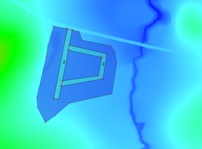
<li>The materials attribute for a number of polygons representing proposed roads in the <b> |
<li>The materials attribute for a number of polygons representing proposed roads in the <b>2d_mat_FMT_M02_DEV_001_R.shp</b> layer have not been assigned and will need to be populated. Assign a Material ID of 2 to these polygons as shown in the figure below. Leave the remaining larger polygon with a Material ID of 1.<br> |
||
<br> |
<br> |
||
[[File:M07 mat roads QGIS.png]]<br> |
[[File:M07 mat roads QGIS.png]]<br> |
||
| Line 15: | Line 15: | ||
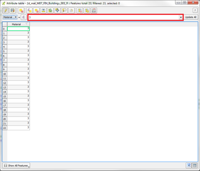
All polygons within the <b> |
All polygons within the <b>2d_mat_FMT_M02_DEV_Buildings_001_R.sho</b> layer represent the buildings of the proposed development and will have the same Material ID of 3. Make use of the ‘Update All’ feature to automatically assign this value to all objects at the same time. Toggle Editing for the '''2d_mat_FMT_M02_DEV_Buildings_001_R''' layer then right-click and select ''Open Attribute Table''. Type '3' in the blank field and select ''Update All'' as shown in the figure below. <br> |
||
<br> |
<br> |
||
[[File:M07 mat update QGIS.png|700px]]<br> |
[[File:M07 mat update QGIS.png|700px]]<br> |
||
<br> |
<br> |
||
<li>Open the Materials.csv file within the <b>TUFLOW\model\</b> folder to observe the Manning’s n values that will be assigned to each Material ID. |
<li>Open the Materials.csv file within the <b>TUFLOW\model\</b> folder to observe the Manning’s n values that will be assigned to each Material ID.</ol> |
||
=Conclusions= |
=Conclusions= |
||
Latest revision as of 18:42, 4 January 2019
Introduction
This page describes the method for using ArcGIS to create the GIS based material types (land use areas) for the proposed development. Once these layers have been setup, surface roughness or bed-resistance values (e.g. Manning’s n) are assigned to each of these land use areas via the materials.csv file present in the model folder.
Method
- Copy the contents of the FMT_tutorial\Module_data\Module_02\Materials into the TUFLOW\model\gis folder. This folder contains the following two layers:
- 2d_mat_FMT_M02_DEV_001_R.shp, and
- 2d_mat_FMT_M02_DEV_Buildings_001_R.shp .
- Open both layers in ArcGIS. The 2d_mat_FMT_M02_DEV_001_R.shp layer contains polygons defining grassed areas and roads within the proposed development. The 2d_mat_FMT_M02_DEV_Buildings_001_R.shp layer contains polygons defining the buildings within the proposed development.
- The materials attribute for a number of polygons representing proposed roads in the 2d_mat_FMT_M02_DEV_001_R.shp layer have not been assigned and will need to be populated. Assign a Material ID of 2 to these polygons as shown in the figure below. Leave the remaining larger polygon with a Material ID of 1.
All polygons within the 2d_mat_FMT_M02_DEV_Buildings_001_R.sho layer represent the buildings of the proposed development and will have the same Material ID of 3. Make use of the ‘Update All’ feature to automatically assign this value to all objects at the same time. Toggle Editing for the 2d_mat_FMT_M02_DEV_Buildings_001_R layer then right-click and select Open Attribute Table. Type '3' in the blank field and select Update All as shown in the figure below.
- Open the Materials.csv file within the TUFLOW\model\ folder to observe the Manning’s n values that will be assigned to each Material ID.


Conclusions
Two 2d_mat GIS layers have been created to define land use categories representing the proposed development. Please return to the main page of the Flood Modeller Module 2 Tutorial