GeoRiver Tips: Difference between revisions
Tuflowduncan (talk | contribs) |
Tuflowduncan (talk | contribs) |
||
| Line 54: | Line 54: | ||
=What is next?= |
=What is next?= |
||
One of the main tools that TUFLOW users have said that they would like is a way of automating the 1D/2D model linking, this is something we are working on solving. It would be great for our development team to hear from TUFLOW users who have niggling or repetitive tasks during model preparation which they think could be automated within GeoRiver®. You can find out more information from the GeoRiver® website on www.storm-georiver.com |
One of the main tools that TUFLOW users have said that they would like is a way of automating the 1D/2D model linking, this is something we are working on solving. It would be great for our development team to hear from TUFLOW users who have niggling or repetitive tasks during model preparation which they think could be automated within GeoRiver®. You can find out more information from the GeoRiver® website on [[www.storm-georiver.com]] |
||
<br> |
<br> |
||
{{Tips Navigation |
{{Tips Navigation |
||
Revision as of 18:55, 8 January 2024
Introduction
GeoRiver® is hydraulic model preparation software that imports data from a multitude of 3rd party formats and has an array of efficient tools to enhance the data before exporting TUFLOW ready files. The software has been developed through a partnership between JBA Consulting Ltd and Storm Geomatics Ltd and aims to reduce flooding by providing greater efficiencies and quality in preparing source data for hydraulic models. TUFLOW users can enjoy a 3 month trial licence of the software for free by contacting Mike Hopkins on (mike.hopkins@storm-geomatics.com). This offer is available to companies who haven’t yet held a GeoRiver® licence. Below is a brief look at how data is imported into GeoRiver®, how it is enhanced and how to export the TUFLOW files.
Importing Data into GeoRiver®
Apart from importing simple XYZ geospatial data, GeoRiver® allows the user to import pre-existing hydraulic model data. At present it is possible to import data from HEC-RAS, Flood Modeller Pro, MIKE11 and EACSD text files. To do this use the drop down menu on the main icon toolbar as shown below.
Tools to efficiently enhance your data
Here are just a few tools that are used for more efficient hydraulic model preparation.
The cross section dxf out/dxf in function is valuable if you do not have a GeoRiver® model with structures already built and have structures on 2D survey/archive drawings that you want to get across to TUFLOW. By having the ability to transfer your GeoRiver® cross sections back and forth to CAD allows the user to easily combine cross sections with structure geometry and then utilise within GeoRiver®.
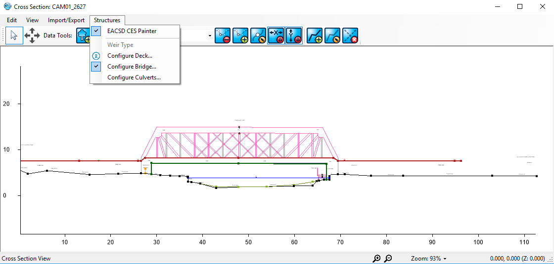
Once the cross section data is in GeoRiver® it can be viewed, enhanced and exported in many ways. One tool which TUFLOW users may find useful is the structure sketching tool, this tool allows the user to specify the structure aperture by sketching directly over the cross section line work.
By clicking on a cross section reference in the left pane of the interface, a cross section can be opened:
In the example below, the user has sketched 4 points on the structural opening of the bridge (in blue) and 10 points on the high chord (in red).
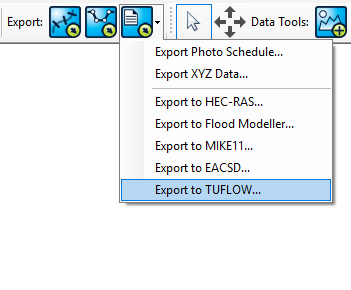
To export TUFLOW files of your river, from the main window select the export options from the menu at the top of the screen and take the TUFLOW option:
There is a further option to export the hard or soft bed cross sections for the river which could be a benefit if looking at dredging effects at a structure. GeoRiver® produces the *.csv files required for TUFLOW which includes the height/width table calculated from the structure opening area.
Many other useful tools
This is just one tool which is useful to speed up model preparation time and also improve the quality of outputs. Users also find it beneficial to have all their source data for the TUFLOW model all in one place and visually accessible. The visual representation is a valuable quality assurance check that the correct data is transferring to the TUFLOW model.
There are many batch tools which can save time such as auto-section renaming to a specified format, auto-photo file renaming associated with cross section, soft/hard bed exports and centreline tools which auto-rename all chainage related sections if the centreline is adjusted….. and more!
What is next?
One of the main tools that TUFLOW users have said that they would like is a way of automating the 1D/2D model linking, this is something we are working on solving. It would be great for our development team to hear from TUFLOW users who have niggling or repetitive tasks during model preparation which they think could be automated within GeoRiver®. You can find out more information from the GeoRiver® website on www.storm-georiver.com
| Up |
|---|


