Difference between revisions of "TUFLOW HR Output"
| (19 intermediate revisions by the same user not shown) | |||
| Line 1: | Line 1: | ||
| − | <font | + | =Introduction= |
| + | High Resolution (HR) Grid/Raster Map Outputs was first introduced in TUFLOW 2020-10-AB release. When an SGS model uses “<font color="blue"><tt>SGS Approach </tt></font> <font color="red"><tt>== </tt></font> <font color="black"><tt>Method C</tt></font>”, the sampled elevations are retained at the end of the geometry processing. These sub-grid elevations include topography modifiers such as breaklines, and they allow a high-resolution elevation check file to be written and used for high resolution depth map outputs. Currently, ASC, FLT and TIF raster formats are supported. | ||
| + | |||
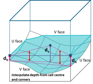
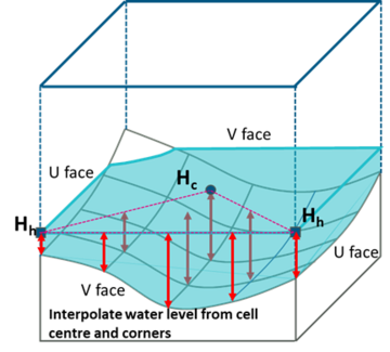
| + | For the HR output the water level at each HR output location is interpolated from the computed 2D water levels. The depth is the difference between the interpolated water level and the sub-grid elevation. This differs from the standard depth output which calculates the depths at cell centres and corners first, then interpolate the depths to the standard output grid locations(default is half the cell size). The difference in the interpolation process is illustrated below. | ||
| + | [[File:Sgs_std_output.png|360px]] [[File:Sgs_hr_output.png|360px]] | ||
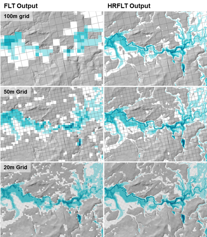
| − | + | The advantage of the HR output is that it can retain the sub-grid detail of the terrain information even at coarse cell size. As compared in the example below, the HR depth output shows clear flow path even at 100m grid. However, nicer depth output does not mean reliable hydraulic result. In fact, the 100m cell size is too coarse to produce reliable/converged hydraulic results for any real-world flood model. It's is strongly recommended that the model convergence/benchmarking tests must be conducted based on the standard map output, and the HR output should be used for presentation purpose only. | |
| − | + | ||
| + | [[File:Sgs_std_vs_hr_output.png|720px]] | ||
=Enable High Resolution Output= | =Enable High Resolution Output= | ||
| Line 16: | Line 21: | ||
The map output data types and output interval can be defined separately for the High Resolution Output formats. For example: | The map output data types and output interval can be defined separately for the High Resolution Output formats. For example: | ||
| − | <font color="blue"><tt>Map Output Interval </tt></font> <font color="red"><tt>== </tt></font> <font color="black"><tt>600</tt></font> <font color="green"><tt> | + | <font color="blue"><tt>Map Output Interval </tt></font> <font color="red"><tt>== </tt></font> <font color="black"><tt>600</tt></font> <font color="green"><tt>! Sets all map output interval to 600 seconds</tt></font> |
| − | <font color="blue"><tt>HRTIF Map Output Interval </tt></font> <font color="red"><tt>== </tt></font> <font color="black"><tt>3600</tt></font> <font color="green"><tt> | + | <font color="blue"><tt>HRTIF Map Output Interval </tt></font> <font color="red"><tt>== </tt></font> <font color="black"><tt>3600</tt></font> <font color="green"><tt>! Sets HR map output interval to 3600 seconds</tt></font> |
The output resolution for high resolution grid output is defined using the following .tcf command: | The output resolution for high resolution grid output is defined using the following .tcf command: | ||
| − | <font color="blue"><tt>HR Grid Output Cell Size </tt></font> <font color="red"><tt>== </tt></font> <font color="black"><tt>0.5</tt></font> <font color="green"><tt> | + | <font color="blue"><tt>HR Grid Output Cell Size </tt></font> <font color="red"><tt>== </tt></font> <font color="black"><tt>0.5</tt></font> <font color="green"><tt>! m or ft</tt></font> |
If this command is omitted, the default output resolution is set as the SGS sampling distance. | If this command is omitted, the default output resolution is set as the SGS sampling distance. | ||
| − | =Water Level Interpolation Method = | + | |
| − | *'' | + | HR outputs are supported by HPC and Quadtree Output Zones. Below is an example of tcf commands to set up HR output in a output zone: |
| + | <font color="blue"><tt>Model Output Zones</tt></font> <font color="red"><tt>==</tt></font> <font color="black"><tt>ZoneA</tt></font><br> | ||
| + | <font color="blue"><tt>Define Output Zone</tt></font> <font color="red"><tt>==</tt></font> <font color="black"><tt>ZoneA</tt></font> | ||
| + | <font color="blue"><tt>Read GIS Output Zone</tt></font> <font color="red"><tt>==</tt></font> <font color="black"><tt>..\model\gis\2d_oz_S05_002_R.shp</tt></font> | ||
| + | <font color="blue"><tt>Write Check Files INCLUDE</tt></font> <font color="red"><tt>==</tt></font> <font color="black"><tt>dem_Z</tt></font> <font color="green"><tt>! includes only dem_Z check file for this output zone</tt></font> | ||
| + | <font color="blue"><tt>Map Output Format</tt></font> <font color="red"><tt>==</tt></font> <font color="black"><tt>HRTIF</tt></font> | ||
| + | <font color="blue"><tt>HRFLT Map Output Data Types</tt></font> <font color="red"><tt>==</tt></font> <font color="black"><tt>h d</tt></font> | ||
| + | <font color="blue"><tt>HRFLT Map Output Interval</tt></font> <font color="red"><tt>==</tt></font> <font color="black"><tt>3600</tt></font> | ||
| + | <font color="blue"><tt>HR Grid Output Cell Size</tt></font> <font color="red"><tt>==</tt></font> <font color="black"><tt>0.5</tt></font> | ||
| + | <font color="blue"><tt>End Define</tt></font> | ||
| + | |||
| + | If HR output is defined in the Map Output Format, a high-resolution DEM_Z check file (DEM_Z_HR) is produced instead of the DEM_Zmin check file. | ||
| + | |||
| + | =Water Level Interpolation Method= | ||
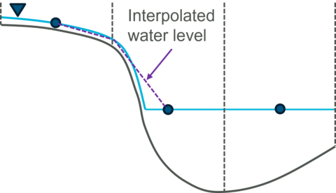
| + | Similar to the standard output, the HR output needs to interpolate cell centre water levels to cell corners. However, the interpolation methods for the standard output (<font color="blue"><tt>Map Output Corner Interpolation </tt></font> <font color="red"><tt>== </tt></font> <font color="black"><tt>Method C</tt></font>) can produce "bumpy" HR water level output in direct rainfall models with steep terrain, as the water level is linearly interpolated from the cell centres/corners, while the change of sub-grid elevations may not be linear. This often happens between fully wet cells and sheet flow cells, as illustrated below. | ||
| + | |||
| + | [[File:corner_h_intp_output.png|480px]] | ||
| + | |||
| + | In the HR water level output, these locations open have high water level with triangular shape. | ||
| + | |||
| + | [[File:HR_Intp_A.png|480px]]<br> | ||
| + | '''HR Interpolation Approach == Method A''' (Gray lines show the triangulation TINs) | ||
| + | |||
| + | Two additional methods have been added for the HR corner water level interpolation: | ||
| + | |||
| + | <font color="blue"><tt>HR Interpolation Approach </tt></font> <font color="red"><tt>== </tt></font> <font color="black"><tt>{Method A} | Method B | Method C</tt></font> | ||
| + | |||
| + | * Method A is the default option that applies the same water level interpolation method used for the standard output. | ||
| + | * Method B performs sheet flow checks at cell faces and ignores the water level from the upstream cell. | ||
| + | * Method C applies the same sheet flow checks as the Method B. In addition, it also uses the number of wet SGS sampled points as a weighting that biases non-sheet flow cells that further improves the mapping to in-stream water levels. | ||
| + | |||
| + | The two images below present the high-resolution water level output at the same location, but with HR Interpolation Approach == Method B and Method C. As can be seen, the water level along the narrow stream is “smoother”. | ||
| + | |||
| + | [[File:HR_Intp_B.png|480px]] [[File:HR_Intp_C.png|480px]]<br> | ||
| + | '''HR Interpolation Approach == Method B (left) and Method C (right)''' | ||
| + | |||
| + | Note that when these two methods are applied, the interpolated corner water level is biased to the non-sheet flow cells, and consequently, sheet flow cells may appear as “dry” cells. The improved approach that takes into the account of the sheet flow water level is currently under development. | ||
| + | |||
| + | Whilst Methods B and C can substantially improve the water surface mapping of SGS models using direct rainfall (rain-on-grid), there will always be inaccuracies with mapping at a higher resolution than the 2D cell resolution due to interpolation and extrapolation. Regardless of the software, the greater the ratio of 2D cell size to the high-resolution DEM cell size, the greater the potential for mapping inaccuracies. Should better mapping accuracy be required, reducing the 2D cell size to compute the spatial variation in water surface and velocities more accurately is, by far, the best course of action. | ||
| + | |||
| + | Please also note that it is not necessary to use these options for non-rainfall on grid models. | ||
| + | |||
=Interpolation near Thin Breakline = | =Interpolation near Thin Breakline = | ||
| − | + | Thin breaklines are often used to define hydraulic controls, such as levees and road embankments. These controls often experience upstream controlled weir flow, where the water levels on the two sides of the breakline can be considerably different. Retaining just one water level (upstream, downstream or average) at output points along the breakline may result in unsatisfactory water level map output as illustrated in the two figures below. This issue becomes more profound the larger the 2D cell size. | |
| − | = | + | |
| − | + | [[File:breakline_h_intp_output.png|480px]]<br> | |
| + | [[File:HR_thin_brk_off.png|480px]]<br> | ||
| + | '''HR Thin Z Line Output Adjustment == OFF''' | ||
| + | |||
| + | A new HR output feature has been introduces to improve the water level interpolation along thin breakline. | ||
| + | Any further questions please email TUFLOW support: [mailto:support@tuflow.com?Subject=TUFLOW%201D%20gates%20help support@tuflow.com] | ||
| + | <font color="blue"><tt>HR Thin Z Line Output Adjustment </tt></font> <font color="red"><tt>== </tt></font> <font color="black"><tt>{OFF} | ON CELL SIDES | ON ALIGNMENT</tt></font> | ||
| + | * “OFF”: the default option, does not apply any water level adjustment. | ||
| + | * “ON CELL SIDES”: two water levels, rather than one, are stored at cell corners selected by thin breaklines. These water levels are used to interpolate HR water levels on either side of thin breaklines. This option produces a sudden drop in water level across the breakline as illustrated in the figure below, noting the sudden drop follows the 2D cell faces where the breakline is applied. | ||
| + | * “ON ALIGNMENT”: As an extension to the “ON CELL SIDES” option, this method moves and aligns the 2D cell corner vertices to the original alignment of the breakline for producing HR water level and depth. The arrows in the figure below show how vertices of the TIN are moved to align with the breakline. This can produce substantially improved high-resolution mapping along thin breaklines with substantial drops in water levels, especially for larger 2D cell sizes. Note that the cell corners are NOT shifted for the hydraulic calculations. | ||
| − | + | [[File:HR_thin_brk_on.png|480px]] [[File:HR_thin_brk_on_adj.png|480px]]<br> | |
| + | '''HR Thin Z Line Output Adjustment == ON CELL SIDES (left) and ON ALIGNMENT (right)''' | ||
| + | Note the this feature (at present) only works for thin breaklines in Z Shape (2d_zsh) layers. Thick/wide breaklines raises more than 1 rows of cell centres and 2 rows of cell faces, and thus do not experience similar HR interpolation issue. | ||
{{Tips Navigation | {{Tips Navigation | ||
|uplink=[[ TUFLOW 1D Channels and Hydraulic Structures | Back to 1D Channels and Hydraulic Structures]] | |uplink=[[ TUFLOW 1D Channels and Hydraulic Structures | Back to 1D Channels and Hydraulic Structures]] | ||
}} | }} | ||
Revision as of 14:03, 20 February 2024
Introduction
High Resolution (HR) Grid/Raster Map Outputs was first introduced in TUFLOW 2020-10-AB release. When an SGS model uses “SGS Approach == Method C”, the sampled elevations are retained at the end of the geometry processing. These sub-grid elevations include topography modifiers such as breaklines, and they allow a high-resolution elevation check file to be written and used for high resolution depth map outputs. Currently, ASC, FLT and TIF raster formats are supported.
For the HR output the water level at each HR output location is interpolated from the computed 2D water levels. The depth is the difference between the interpolated water level and the sub-grid elevation. This differs from the standard depth output which calculates the depths at cell centres and corners first, then interpolate the depths to the standard output grid locations(default is half the cell size). The difference in the interpolation process is illustrated below.
The advantage of the HR output is that it can retain the sub-grid detail of the terrain information even at coarse cell size. As compared in the example below, the HR depth output shows clear flow path even at 100m grid. However, nicer depth output does not mean reliable hydraulic result. In fact, the 100m cell size is too coarse to produce reliable/converged hydraulic results for any real-world flood model. It's is strongly recommended that the model convergence/benchmarking tests must be conducted based on the standard map output, and the HR output should be used for presentation purpose only.
Enable High Resolution Output
To produce high-resolution output, add “HRASC”, “HRFLT” or “HRTIF” to the “Map Output Format ==” command, for example:
Map Output Format == XMDF TIF HRTIF
At the moment, only water level and depth are supported as the High Resolution Output formats, i.e.:
HRTIF Map Output Data Types == h d
The map output data types and output interval can be defined separately for the High Resolution Output formats. For example:
Map Output Interval == 600 ! Sets all map output interval to 600 seconds
HRTIF Map Output Interval == 3600 ! Sets HR map output interval to 3600 seconds
The output resolution for high resolution grid output is defined using the following .tcf command:
HR Grid Output Cell Size == 0.5 ! m or ft
If this command is omitted, the default output resolution is set as the SGS sampling distance.
HR outputs are supported by HPC and Quadtree Output Zones. Below is an example of tcf commands to set up HR output in a output zone:
Model Output Zones == ZoneA

Define Output Zone == ZoneA
   Read GIS Output Zone == ..\model\gis\2d_oz_S05_002_R.shp
   Write Check Files INCLUDE == dem_Z ! includes only dem_Z check file for this output zone
   Map Output Format == HRTIF
   HRFLT Map Output Data Types == h d
   HRFLT Map Output Interval == 3600
   HR Grid Output Cell Size == 0.5
End Define
If HR output is defined in the Map Output Format, a high-resolution DEM_Z check file (DEM_Z_HR) is produced instead of the DEM_Zmin check file.
Water Level Interpolation Method
Similar to the standard output, the HR output needs to interpolate cell centre water levels to cell corners. However, the interpolation methods for the standard output (Map Output Corner Interpolation == Method C) can produce "bumpy" HR water level output in direct rainfall models with steep terrain, as the water level is linearly interpolated from the cell centres/corners, while the change of sub-grid elevations may not be linear. This often happens between fully wet cells and sheet flow cells, as illustrated below.
In the HR water level output, these locations open have high water level with triangular shape.
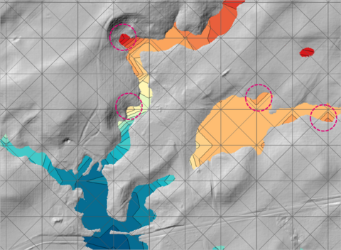
HR Interpolation Approach == Method A (Gray lines show the triangulation TINs)
Two additional methods have been added for the HR corner water level interpolation:
HR Interpolation Approach == {Method A} | Method B | Method C
- Method A is the default option that applies the same water level interpolation method used for the standard output.
- Method B performs sheet flow checks at cell faces and ignores the water level from the upstream cell.
- Method C applies the same sheet flow checks as the Method B. In addition, it also uses the number of wet SGS sampled points as a weighting that biases non-sheet flow cells that further improves the mapping to in-stream water levels.
The two images below present the high-resolution water level output at the same location, but with HR Interpolation Approach == Method B and Method C. As can be seen, the water level along the narrow stream is “smoother”.
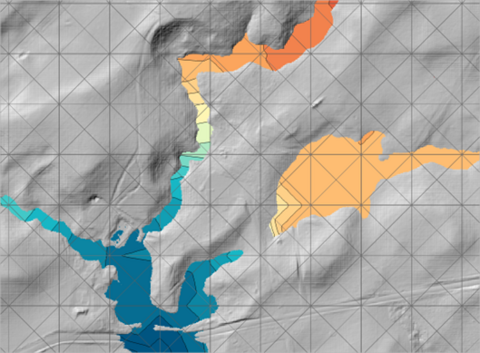
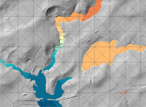
HR Interpolation Approach == Method B (left) and Method C (right)
Note that when these two methods are applied, the interpolated corner water level is biased to the non-sheet flow cells, and consequently, sheet flow cells may appear as “dry” cells. The improved approach that takes into the account of the sheet flow water level is currently under development.
Whilst Methods B and C can substantially improve the water surface mapping of SGS models using direct rainfall (rain-on-grid), there will always be inaccuracies with mapping at a higher resolution than the 2D cell resolution due to interpolation and extrapolation. Regardless of the software, the greater the ratio of 2D cell size to the high-resolution DEM cell size, the greater the potential for mapping inaccuracies. Should better mapping accuracy be required, reducing the 2D cell size to compute the spatial variation in water surface and velocities more accurately is, by far, the best course of action.
Please also note that it is not necessary to use these options for non-rainfall on grid models.
Interpolation near Thin Breakline
Thin breaklines are often used to define hydraulic controls, such as levees and road embankments. These controls often experience upstream controlled weir flow, where the water levels on the two sides of the breakline can be considerably different. Retaining just one water level (upstream, downstream or average) at output points along the breakline may result in unsatisfactory water level map output as illustrated in the two figures below. This issue becomes more profound the larger the 2D cell size.
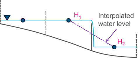
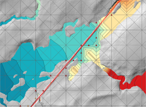
HR Thin Z Line Output Adjustment == OFF
A new HR output feature has been introduces to improve the water level interpolation along thin breakline. Any further questions please email TUFLOW support: support@tuflow.com
HR Thin Z Line Output Adjustment == {OFF} | ON CELL SIDES | ON ALIGNMENT
- “OFF”: the default option, does not apply any water level adjustment.
- “ON CELL SIDES”: two water levels, rather than one, are stored at cell corners selected by thin breaklines. These water levels are used to interpolate HR water levels on either side of thin breaklines. This option produces a sudden drop in water level across the breakline as illustrated in the figure below, noting the sudden drop follows the 2D cell faces where the breakline is applied.
- “ON ALIGNMENT”: As an extension to the “ON CELL SIDES” option, this method moves and aligns the 2D cell corner vertices to the original alignment of the breakline for producing HR water level and depth. The arrows in the figure below show how vertices of the TIN are moved to align with the breakline. This can produce substantially improved high-resolution mapping along thin breaklines with substantial drops in water levels, especially for larger 2D cell sizes. Note that the cell corners are NOT shifted for the hydraulic calculations.
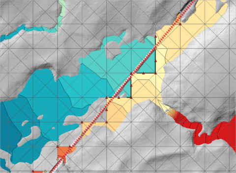
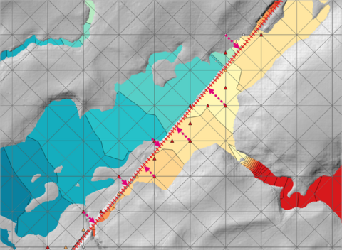
HR Thin Z Line Output Adjustment == ON CELL SIDES (left) and ON ALIGNMENT (right)
Note the this feature (at present) only works for thin breaklines in Z Shape (2d_zsh) layers. Thick/wide breaklines raises more than 1 rows of cell centres and 2 rows of cell faces, and thus do not experience similar HR interpolation issue.
| Up |
|---|
