Difference between revisions of "Check Files 2d zpt"
| (4 intermediate revisions by 2 users not shown) | |||
| Line 1: | Line 1: | ||
| − | This GIS | + | This GIS check file contains information on the final 2D elevations in the TUFLOW model (2D Zpts). This final elevation is after all elevation commands (TIN, Grid, breakline etc.) have been read into the model. These are the elevations that are used in the computation. This check files allows you to see the elevations at any point and can therefore be used for cross-checking that the elevations have been interpolate correctly.<br> |
| + | <br> | ||
| + | This check file can be very large and not necessarily easy to visualise, the [[Check_Files_2d_DEM_Z | DEM_Z check file]] contains a raster version of the elevations and is nicer for visualisation (in particular when looking at the entire model or large sections of the model). The _zpt_check file is more suited to viewing the values at individual zpts. | ||
| + | <br> | ||
<br> | <br> | ||
'''Attributes of _zpt_check'''<br> | '''Attributes of _zpt_check'''<br> | ||
| Line 11: | Line 14: | ||
|- | |- | ||
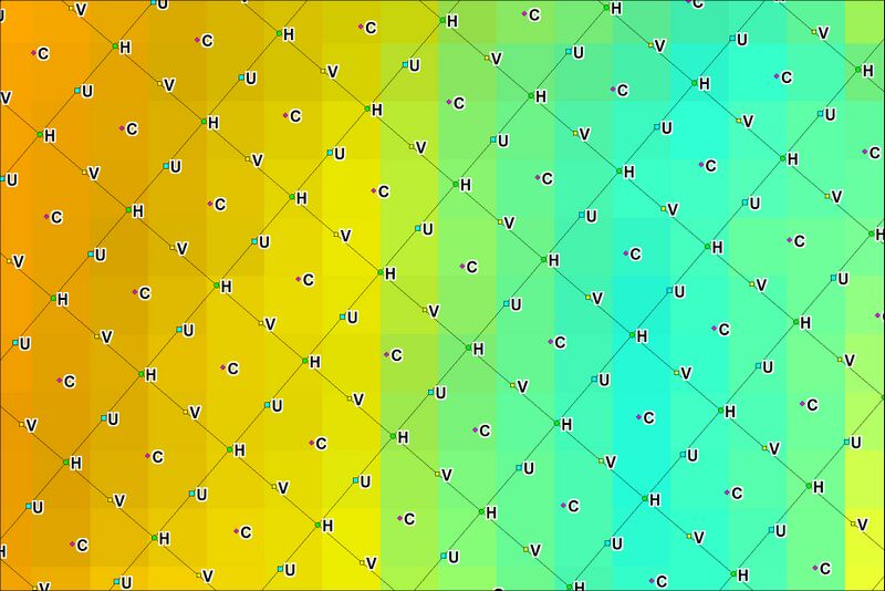
| Type||The type of point - in TUFLOW the topography is defined by the elevations at the cell centres, mid-sides and cell corners.<br> | | Type||The type of point - in TUFLOW the topography is defined by the elevations at the cell centres, mid-sides and cell corners.<br> | ||
| − | Please refer to | + | Please refer to the <u>[https://downloads.tuflow.com/TUFLOW/Releases/Latest/TUFLOW%20Manual.pdf TUFLOW Manual]</u> for more detailed description of these.<br> |
<br> | <br> | ||
The types are:<br> | The types are:<br> | ||
| Line 19: | Line 22: | ||
* '''H''' The ZH - the cell corner to the top right hand corner of the cell | * '''H''' The ZH - the cell corner to the top right hand corner of the cell | ||
|- | |- | ||
| − | | Elevation||The | + | | Elevation (Zmin if SGS is used)||The elevation within the cell. If SGS is used, minimum elevation within the cell. |
| + | |- | ||
| + | | Domain_Index||The index of the model domain. This is the order with <tt><font color="blue>Start 2D Domain</font><font color="red"> == </font><Domain Name></tt> commands appears in the TCF control file. For a single domain model this will be 1. | ||
| + | |- | ||
| + | !colspan="2" | If SGS is used... | ||
| + | |- | ||
| + | | ZExact||The elevation at the exact location of the cell centre, face mid-point, or cell corner. | ||
| + | |- | ||
| + | | ZAvg||The average (mean) elevation of the sampled values. | ||
| + | |- | ||
| + | | ZMed||The median elevation of the sampled values. | ||
|- | |- | ||
| − | | | + | | ZMax||The maximum elevation, i.e. the elevation at which the cell area or cell face flow width is fully wet. |
| + | |- | ||
| + | | ZOut|| The elevation used for the SGS Depth Output. | ||
|} | |} | ||
| + | <br> | ||
| + | |||
| + | In the image below the TUFLOW model grid is shown with the 2d_zpt check file labelled by the '''Type''' attribute.<br> | ||
| + | <br> | ||
| + | [[File:Check Files 2d zpt 01.jpg|800px]] | ||
| + | <br> | ||
| + | <br> | ||
| + | In the image below the TUFLOW model grid is shown with the 2d_zpt check file labelled by the '''Elevation''' attribute.<br> | ||
| + | <br> | ||
| + | [[File:Check Files 2d zpt 02.jpg|800px]] | ||
| + | <br> | ||
| + | <br> | ||
| + | |||
| + | |||
| + | {{Tips Navigation | ||
| + | |uplink=[[TUFLOW_Check_Files | TUFLOW Check Files]] | ||
| + | }} | ||
Latest revision as of 16:20, 12 August 2024
This GIS check file contains information on the final 2D elevations in the TUFLOW model (2D Zpts). This final elevation is after all elevation commands (TIN, Grid, breakline etc.) have been read into the model. These are the elevations that are used in the computation. This check files allows you to see the elevations at any point and can therefore be used for cross-checking that the elevations have been interpolate correctly.
This check file can be very large and not necessarily easy to visualise, the DEM_Z check file contains a raster version of the elevations and is nicer for visualisation (in particular when looking at the entire model or large sections of the model). The _zpt_check file is more suited to viewing the values at individual zpts.
Attributes of _zpt_check
| Attribute Name | Attribute Description |
|---|---|
| n | Row number in the TUFLOW domain |
| m | Column number in the TUFLOW domain |
| Type | The type of point - in TUFLOW the topography is defined by the elevations at the cell centres, mid-sides and cell corners. Please refer to the TUFLOW Manual for more detailed description of these.
|
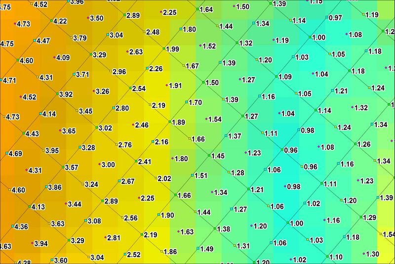
| Elevation (Zmin if SGS is used) | The elevation within the cell. If SGS is used, minimum elevation within the cell. |
| Domain_Index | The index of the model domain. This is the order with Start 2D Domain == <Domain Name> commands appears in the TCF control file. For a single domain model this will be 1. |
| If SGS is used... | |
| ZExact | The elevation at the exact location of the cell centre, face mid-point, or cell corner. |
| ZAvg | The average (mean) elevation of the sampled values. |
| ZMed | The median elevation of the sampled values. |
| ZMax | The maximum elevation, i.e. the elevation at which the cell area or cell face flow width is fully wet. |
| ZOut | The elevation used for the SGS Depth Output. |
In the image below the TUFLOW model grid is shown with the 2d_zpt check file labelled by the Type attribute.

In the image below the TUFLOW model grid is shown with the 2d_zpt check file labelled by the Elevation attribute.

| Up |
|---|