Difference between revisions of "Check Files 2d input layers"
Jump to navigation
Jump to search
| (2 intermediate revisions by 2 users not shown) | |||
| Line 1: | Line 1: | ||
| − | This pages contains information on the attributes of the _input_layers check file. This file is always written in the MapInfo .mif / .mid file format. No spatial objects are written into the .mif file (these are all "None" objects. However, the tabular data in the .mid file contains information about the input files that have been opened. As the .mid file is a simple comma separated file, this file can be easily scripted. | + | This pages contains information on the attributes of the _input_layers check file. This file is only created when using MapInfo file format and therefore, this file is always written in the MapInfo .mif / .mid file format. No spatial objects are written into the .mif file (these are all "None" objects. However, the tabular data in the .mid file contains information about the input files that have been opened. As the .mid file is a simple comma separated file, this file can be easily scripted. |
'''Attributes of _input_layers.mif file'''<br> | '''Attributes of _input_layers.mif file'''<br> | ||
| Line 6: | Line 6: | ||
! style="background-color:#005581; font-weight:bold; color:white;" width=75%| Attribute Description | ! style="background-color:#005581; font-weight:bold; color:white;" width=75%| Attribute Description | ||
|- | |- | ||
| − | | ID||A numerical GIS ID for the layer, this is a unique ID that TUFLOW users internally to track the layer, it is not output in the | + | | ID||A numerical GIS ID for the layer, this is a unique ID that TUFLOW users internally to track the layer, it is not output in the TLF. |
|- | |- | ||
| − | | Open_ID||The numerical GIS ID of the layer, as written in the | + | | Open_ID||The numerical GIS ID of the layer, as written in the TLF file, for example <tt>GIS Layer assigned ID of 12</tt>. This number may not be unique. Once the GIS layer has been closed by TUFLOW, the "Open_ID" can be used again when further GIS layers are opened. |
|- | |- | ||
| Layer||The file path and filename of the input layer. | | Layer||The file path and filename of the input layer. | ||
|} | |} | ||
| + | <br> | ||
| + | An example input layer check file is shown in MapInfo below. There are no GIS objects only the tabular data.<br> | ||
| + | <br> | ||
| + | [[File:Check Files input layer 01.JPG]] | ||
<br><br> | <br><br> | ||
| − | |||
| − | [[ | + | |
| + | {{Tips Navigation | ||
| + | |uplink=[[TUFLOW_Check_Files | TUFLOW Check Files]] | ||
| + | }} | ||
Latest revision as of 09:26, 26 August 2024
This pages contains information on the attributes of the _input_layers check file. This file is only created when using MapInfo file format and therefore, this file is always written in the MapInfo .mif / .mid file format. No spatial objects are written into the .mif file (these are all "None" objects. However, the tabular data in the .mid file contains information about the input files that have been opened. As the .mid file is a simple comma separated file, this file can be easily scripted.
Attributes of _input_layers.mif file
| Attribute Name | Attribute Description |
|---|---|
| ID | A numerical GIS ID for the layer, this is a unique ID that TUFLOW users internally to track the layer, it is not output in the TLF. |
| Open_ID | The numerical GIS ID of the layer, as written in the TLF file, for example GIS Layer assigned ID of 12. This number may not be unique. Once the GIS layer has been closed by TUFLOW, the "Open_ID" can be used again when further GIS layers are opened. |
| Layer | The file path and filename of the input layer. |
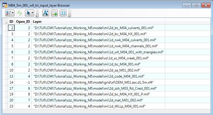
An example input layer check file is shown in MapInfo below. There are no GIS objects only the tabular data.

| Up |
|---|