TUFLOW Message 1433: Difference between revisions
No edit summary |
Ellis Symons (talk | contribs) No edit summary |
||
| Line 3: | Line 3: | ||
|alt_msg=ERROR 1433 - Upper Transition Elevation is lower than Lower Transition Elevation for an Arch Bridge channel.<br> |
|alt_msg=ERROR 1433 - Upper Transition Elevation is lower than Lower Transition Elevation for an Arch Bridge channel.<br> |
||
|type=[[WARNING]]<br>[[ERROR]] |
|type=[[WARNING]]<br>[[ERROR]] |
||
|message_desc=There was an issue in reading the binary (xf) version of the file. |
|message_desc=<b>WARNING 1433:</b> There was an issue in reading the binary (xf) version of the file. |
||
| ⚫ | |||
<b>ERROR 1433:</b> For arch bridge channels (BArch), the start of the orifice flow transition needs to be lower than the end of the orifice transition. That is, the arch bridge channel will transition from using the arch bridge approach into orifice flow as the water level approaches the bridge obvert if the orifice flow flag is turned on (the default is turned off). |
|||
| ⚫ | |||
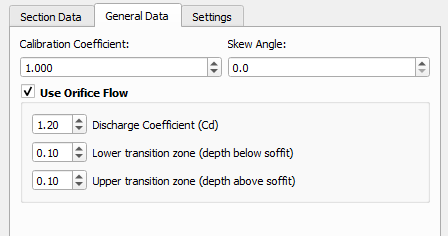
<b>ERROR 1433:</b> Ensure that the lower transition value is lower than the upper transition value in the BArch channel GIS attributes. "EntryC_or_WSa" = Lower transition (measured as depth below obvert) and "ExitC_or_WSb" = upper transition (measured as depth above obvert). If using the arch bridge editor in QGIS, the transition values can be found on the 'General Data' tab. |
|||
[[file: Arch_bridge_editor_general_tab.png]] |
|||
|uplink=[[1xxx_TUFLOW_Messages|1xxx Messages]] |
|uplink=[[1xxx_TUFLOW_Messages|1xxx Messages]] |
||
Revision as of 17:56, 1 May 2025
TUFLOW Message
WARNING 1433 - Reading XF file failed. Reverting to original file.
Alternate Message
ERROR 1433 - Upper Transition Elevation is lower than Lower Transition Elevation for an Arch Bridge channel.
Description
WARNING 1433: There was an issue in reading the binary (xf) version of the file.
ERROR 1433: For arch bridge channels (BArch), the start of the orifice flow transition needs to be lower than the end of the orifice transition. That is, the arch bridge channel will transition from using the arch bridge approach into orifice flow as the water level approaches the bridge obvert if the orifice flow flag is turned on (the default is turned off).
Suggestions
WARNING 1433: The original data is being re-read from the .csv file.
ERROR 1433: Ensure that the lower transition value is lower than the upper transition value in the BArch channel GIS attributes. "EntryC_or_WSa" = Lower transition (measured as depth below obvert) and "ExitC_or_WSb" = upper transition (measured as depth above obvert). If using the arch bridge editor in QGIS, the transition values can be found on the 'General Data' tab.
| Up |
|---|
