Arc Export Raster to asc: Difference between revisions
Jump to navigation
Jump to search
Content deleted Content added
No edit summary |
Chris Huxley (talk | contribs) No edit summary |
||
| Line 14: | Line 14: | ||
=Tips= |
=Tips= |
||
To convert between the .asc and .flt format the TUFLOW utility "asc_to_asc" can be used. |
To convert between the .asc and .flt format the TUFLOW utility "asc_to_asc" can be used. |
||
<br> |
|||
{{Tips Navigation |
|||
|uplink=[[ArcGis_Tips | Back to ArcGIS]]}} |
|||
Revision as of 06:09, 31 January 2015
Introduction
TUFLOW can directly read elevation data from a Digital Elevation Model (DEM). The format recognised by TUFLOW is ESRI ASCII Grid (.asc), this is an open text format that is recognised by a wide range of software including ArcGIS, MapInfo and Quantum GIS. The instructions below outline the process for exporting from a raster layer in ArcMap to a ESRI ASCII grid.
TUFLOW can also read .asc format data for setting a number of model parameters including, initial water level (Read GRID IWL == ), Soil Type (Read Grid Soil == ), roughness (Read Grid CnM == ), storage reduction factor (Read Grid SRF == ).
Method
- Open the raster layer that you wish to convert.
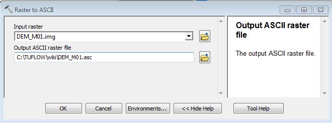
- In the Arc Toolbox menu, select Conversion Tools >> From Raster >> Raster to ASCII
- In the dialogue, select the desired input raster and set the output filename. Note, there is no set extension for this file type, both .asc and .txt are widely used.
- The DEM file is ready for reading into TUFLOW.


Tips
To convert between the .asc and .flt format the TUFLOW utility "asc_to_asc" can be used.
| Up |
|---|