Difference between revisions of "HEC-RAS to TUFLOW"
Chris Huxley (talk | contribs) |
Chris Huxley (talk | contribs) |
||
| Line 60: | Line 60: | ||
The utility is currently limited to being run using a batch file. To create a batch file: | The utility is currently limited to being run using a batch file. To create a batch file: | ||
<ol> | <ol> | ||
| − | <li> Create a new text file in the same location as the sdf file. The name is arbitrary but the file must have the extension ".bat". For example | + | <li> Create a new text file in the same location as the sdf file. The name is arbitrary but the file must have the extension ".bat". For example, "run_sdf_to_GIS.bat". |
<li> Enter the relevant command syntax to the batch file (refer to the 'Input Flags' table and examples provided below). | <li> Enter the relevant command syntax to the batch file (refer to the 'Input Flags' table and examples provided below). | ||
<li>Double click the batch file in windows explore to execute the model conversion.<br> | <li>Double click the batch file in windows explore to execute the model conversion.<br> | ||
Revision as of 08:28, 7 February 2015
Introduction
This page outlines some utilities that may be used to convert HEC-RAS model files into a format which compatible with TUFLOW.
If you have any suggestions to be included in these pages, please email support@tuflow.com.
Geometry Conversion (sdf_to_gis.exe)
The sdf_to_gis.exe utility is available for download from the TUFLOW website, it converts HEC-RAS geometric data into a TUFLOW compatible GIS (mif and shp) and csv input format. The utility outputs include:
- Centerline location data in GIS format
- Cross-section locations in GIS format
- Cross-section data in csv format
Note: This utility is currently still in its beta testing phase. Output should be carefully quality checked.
The steps required to use this utility are:
- Export the HEC-RAS geometry data into sdf format
- Create a GIS projection file for the conversion
- Create a batch file to run the utility
- Double click the batch file in windows explorer to execute the model conversion
Input Data Processing
The HEC-RAS model inputs need to be in SDF format (HEC-RAS export format), and must be geo-referenced using a real world projection.
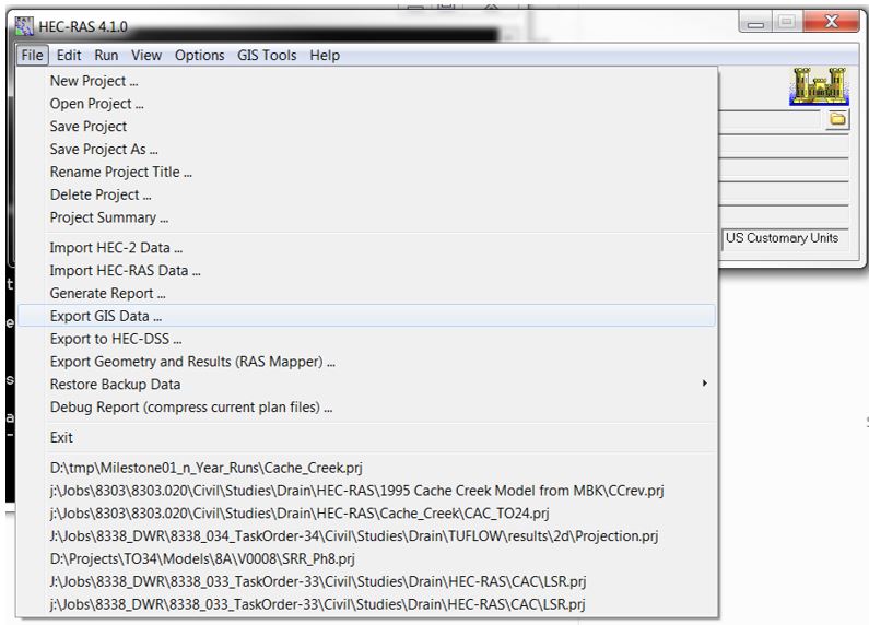
Export the HEC-RAS sdf file using: File >> Export GIS Data...
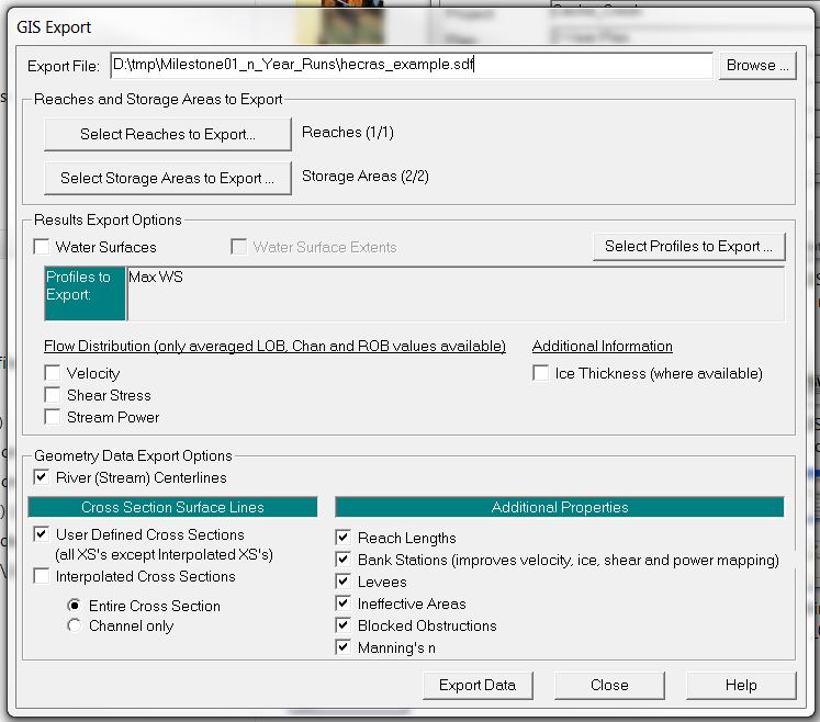
Select the following items within the GIS Export window:
- River (Stream) Centerlines
- User Defined Cross Sections
- Entire Cross Section
- Reach Lengths
- Bank Stations
- Levees
- Ineffective Areas
- Blocked Obstructions
- Manning's n
Utility Execution
The utility requires GIS projection information to correctly translate the spatial dataset from SDF format to *mif or *.shp format. This is done by including either a projection or header file in the same folder directory as the SDF file. The utility will use the projection information from this file for the data conversion.
- mif format input requirement: Projection.mif or Header.mif
- shp format input requirement: Projection.prj or Header.prj
The following error message will be produced if projection information is not available:
ERROR - A Header.prj or Projection.prj file does not exist in folder
The utility is currently limited to being run using a batch file. To create a batch file:
- Create a new text file in the same location as the sdf file. The name is arbitrary but the file must have the extension ".bat". For example, "run_sdf_to_GIS.bat".
- Enter the relevant command syntax to the batch file (refer to the 'Input Flags' table and examples provided below).
- Double click the batch file in windows explore to execute the model conversion.
Input Flags
A list of the input switches is provided below:
| Switch | Description |
|---|---|
| "-mif" | The output format will be the MapInfo Interchange format (.mif/.mid) recognised by most GIS software |
| "-shp" | The output format will be the ArcGIS Shapefile format. This can be opened directly in ArcMap, QGIS or SAGA (and most GIS software) |
| "-notrim | This command will prevent the utility from trimming cross-section data at levee markers. This is a non-default option due to most users converting HEC-RAS creek cross-section data into a TUFLOW 1D compatible format, whilst the surrounding floodplain in 2D areas are modeled in 2D (not requiring HEC-RAS inputs) |
.
Example Syntax
Description: Convert HEC-RAS sdf data to mif format, trimming cross-section at levee markers (default trim option):
Description: Convert HEC-RAS sdf data to shp format, trimming cross-section at levee markers (default trim option):
Description: Convert HEC-RAS sdf data to mif format, not trimming cross-section at levee markers:
Description: Convert HEC-RAS sdf data to shp format, not trimming cross-section at levee markers:
Note The above listed syntax assumes that the sdf_to_gis.exe, hecras_example.sdf file and associated batch file are located within the same directory. If not the case, absolute file path referencing will be required. For example:
Utility Output
sdf_to_gis.exe will output five GIS files and a series of csv files, one for each cross-section.
TUFLOW Input
- 1d_xs_<sdf_filename>_surf_line:
This dataset defines the location of the cross-sections. The file uses a format that is compatible with TUFLOW. The field attributes for "Source", "Type" and "Flags" have been pre-filled. - Cross-section csv files:
This dataset defines the cross-section properties. Across channel distance, channel elevation and manning's roughness have been pre-filled with the csv datasets.
Check Files
- <sdf_filename>_streams:
This file defines the centerline of the channel. This centerline data can be split using the cross-section data to define the 1D channel (1d_nwk) in a TUFLOW model. The following field attributes should be used if this check file is converted into a TUFLOW input:- "Len_or_ANA"= 0 (the length of the line/polyline is used).
- "n_or_n_F" = 1 (materials are being defined in the cross-section csv files. n_or_n_F is a multiplication factor of the cross-section manning’s n value).
- "US_Invert"= -99999 (the bed of the channel cross-section is used).
- "DS_Invert"= -99999 (the bed of the channel cross-section is used).
- <sdf_filename>_cut_line:
Echo of the cross-section line (non-trimmed). - <sdf_filename>_levee_pts:
Points defining the intersection of the cross-section line with the levee used to trim the cross-section dataset. - <sdf_filename>_surf_line:
Point dataset reporting the location of each elevation values within the csv cross-section dataset.
Geometry Conversion (miTools)
MiTools is a MapInfo add-on that is available for download from the TUFLOW website.
MiTools can be used to convert HEC-RAS geometry cross-section data into mif/mid spatial and csv tabular format for direct input into TUFLOW.
The tool provides various user options, such as:
- Inclusion of manning n within the cross-section csv dataset.
- Various overbank trim options (no trimming, deactivate or trim).
Refer to the miTools Tips and Tricks section for more information about miTools.
Boundary Condition Conversion
coming soon

