Difference between revisions of "1D Open Channels"
Rohan.king (talk | contribs) m (→Basic Commands) |
Rohan.king (talk | contribs) m |
||
| Line 17: | Line 17: | ||
<br> | <br> | ||
The tutorial model [[Tutorial_Module04 | here]] runs through the necessary layers and setup for a 1D open channel within a model. | The tutorial model [[Tutorial_Module04 | here]] runs through the necessary layers and setup for a 1D open channel within a model. | ||
| + | |||
| + | =Typical check files used= | ||
<br> | <br> | ||
<br> | <br> | ||
Any further questions please email TUFLOW support: [mailto:support@tuflow.com support@tuflow.com] | Any further questions please email TUFLOW support: [mailto:support@tuflow.com support@tuflow.com] | ||
Revision as of 03:14, 10 February 2016
Page Under Construction
Introduction
Open waterways (channels) are most commonly modelled as "S" type channels, the S signifies a sloping channel that can handle steep, super-critical flows. Open channels can either be modeled as an inertial or non-inertial channel, the latter removes the Courant stability condition and is useful for stabilizing very short S channels with high velocities.
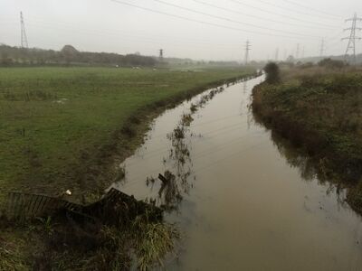
Example of an open channel that could be modelled in 1D

Basic Commands
Within the *.ecf the following commands and files are at a minimum required to a model an open channel:
Read GIS Network ==..\model\mi\1d_nwke_xxxxx.MIF ! network layer containing "S" channel alignments
Read GIS Table Links ==..\model\mi\1d_xs_xxxxx.MIF ! corresponding cross-section polylines
The tutorial model here runs through the necessary layers and setup for a 1D open channel within a model.
Typical check files used
Any further questions please email TUFLOW support: support@tuflow.com