1D-2D Flood Modeller-TUFLOW: Difference between revisions
Tuflowduncan (talk | contribs) |
No edit summary |
||
| (10 intermediate revisions by 2 users not shown) | |||
| Line 1: | Line 1: | ||
<ol> |
<ol> |
||
=THIS PAGE IS CURRENTLY UNDER CONSTRUCTION= |
|||
=Introduction= |
=Introduction= |
||
TUFLOW models can be configured to dynamically link to Flood Modeller by utilising a water level boundary to the 2D cells along the 1D/2D interface. In the 2D boundary condition (2d_bc) GIS layer, the location at which this link occurs is defined. The 2D water level applied at the 2D boundary cells is calculated |
TUFLOW models can be configured to dynamically link to Flood Modeller by utilising a water level boundary to the 2D cells along the 1D/2D interface. In the 2D boundary condition (2d_bc) GIS layer, the location at which this link occurs is defined. The 2D water level applied at the 2D boundary cells is calculated by the Flood Modeller 1D model. The terminology used in TUFLOW is a '''HX''' type boundary on the 2D cells, with the '''H''' indicating that a '''H'''ead (water level) boundary is used and the '''X''' indicating the value is coming from an e'''X'''ternal model (in this case Flood Modeller). |
||
<br> |
<br> |
||
Depending on the water level in the surrounding 2D cells, flow can either enter or leave the HX cells. The volume of water entering or leaving the 2D boundary is added or subtracted from the 1D Flood Modeller model to preserve volume. |
Depending on the water level in the surrounding 2D cells, flow can either enter or leave the HX cells. The volume of water entering or leaving the 2D boundary is added or subtracted from the 1D Flood Modeller model to preserve volume. The HX lines must be connected to the 1D Flood Modeller model. This is done using CN type lines in the 2d_bc layer, where a CN line is connected to the HX line, the water level from the 1D Flood Modeller nodes is transferred to the HX line. In between 1D nodes, a linear interpolation of water level is applied. This is shown in the figure below. |
||
<br> |
<br> |
||
[[File:1d 2d FM link 01.jpg|800px]] |
[[File:1d 2d FM link 01.jpg|800px]] |
||
<br> |
<br> |
||
Once the water level in Flood Modeller exceeds the elevation in the boundary cell water can enter or leave the model. Similar to a Flood Modeller lateral spill or lateral inflow, the discharge is distributed laterally along the length of the HX line. Note that it is the elevation of the HX boundary cell centres that determines when the spill starts to occur and not the cross section within Flood Modeller. If there is a levee or flood defence, it is important that we use breaklines in the model to ensure that the elevations of the 2D cells are consistent with the levee crest. The next four images show a section view of the 1D/2D link and how this may progress during a flood event.<br> |
Once the water level in Flood Modeller exceeds the elevation in the boundary cell, water can enter or leave the model. Similar to a Flood Modeller lateral spill or lateral inflow, the discharge is distributed laterally along the length of the HX line. Note that it is the elevation of the HX boundary cell centres that determines when the spill starts to occur and not the cross section within Flood Modeller. If there is a levee or flood defence, it is important that we use breaklines in the model to ensure that the elevations of the 2D cells are consistent with the levee crest. The next four images show a section view of the 1D/2D link and how this may progress during a flood event.<br> |
||
<br> |
<br> |
||
[[File:M04 1d2d 01.png|300px]] |
[[File:M04 1d2d 01.png|300px]] |
||
| Line 16: | Line 14: | ||
[[File:M04 1d2d 04.png|300px]] |
[[File:M04 1d2d 04.png|300px]] |
||
Often HX lines are located along the top of |
Often HX lines are located along the top of an embankment (natural or artificial) or flood defence running along the river bank. When carving a 1D channel through a 2D domain, the HX line must be either on the top of the embankment or on the inside of the embankment (closest to the channel). If the HX line is located on the other side of the embankment away from the channel, the effect of the embankment on water flow is <u>'''not'''</u> modelled. In the image above, it can be seen that the boundary cell is along the embankment and the interaction between the channel and the floodplain (1D and 2D) occurs at the correct elevation. <br> |
||
=Building a Flood Modeller-TUFLOW 1D-2D HX Connection= |
=Building a Flood Modeller-TUFLOW 1D-2D HX Connection= |
||
| Line 25: | Line 23: | ||
<br> |
<br> |
||
The digitised direction of the HX and CN lines is not important. The CN lines however should be digitised approximately perpendicular to the direction of flow. Two CN lines are digitised for each node and snapped to the HX boundary lines along the left and right banks at vertices. Both CN and HX lines are digitised within the same 2d_bc file, on a basic approach, you only need to input the '''type''' attribute (either '''CN''' or '''HX'''). It is also recommended to input an '''f''' attribute value of '''1''' for CN lines for clarity, however if left at zero TUFLOW will by default change this value to 1. There are a range of Flags that can be used within the 2d_bc file, also D values to change elevations of the link cells and also A values to change the storage across the cells. Further information on these can be found within the TUFLOW |
The digitised direction of the HX and CN lines is not important. The CN lines however should be digitised approximately perpendicular to the direction of flow. Two CN lines are digitised for each node and snapped to the HX boundary lines along the left and right banks at vertices. Both CN and HX lines are digitised within the same 2d_bc file, on a basic approach, you only need to input the '''type''' attribute (either '''CN''' or '''HX'''). It is also recommended to input an '''f''' attribute value of '''1''' for CN lines for clarity, however if left at zero TUFLOW will by default change this value to 1. There are a range of Flags that can be used within the 2d_bc file, also D values to change elevations of the link cells and also A values to change the storage across the cells. Further information on these can be found within the <u>[https://docs.tuflow.com/classic-hpc/manual/latest/ TUFLOW Manual]</u>. |
||
<br> |
<br> |
||
The HX boundary lines should be digitised along the top of each bank such that the width between the lines approximately correlates to the width of the 1D channel. This is important so as not to either over/under compensate flow area between the two solvers. |
The HX boundary lines should be digitised along the top of each bank such that the width between the lines approximately correlates to the width of the 1D channel. This is important so as not to either over/under compensate flow area between the two solvers. |
||
| Line 39: | Line 37: | ||
<br> |
<br> |
||
=Building a Flood Modeller-TUFLOW 1D-2D SX Connection= |
=Building a Flood Modeller-TUFLOW 1D-2D SX Connection= |
||
Flood Modeller can also be dynamically linked to outflow directly to the 2D TUFLOW domain at the start or end of a |
Flood Modeller can also be dynamically linked to outflow directly to the 2D TUFLOW domain at the start or end of a Flood Modeller reach. This can relate to tributary channels, small drainage channels, and also the main channel if exiting into a 2D estuarine environment for example. |
||
<br> |
<br> |
||
The image below shows the representation within Flood Modeller and TUFLOW of a simple flume model. As you can see in Flood Modeller, the end open channel section '''FMT_003''' links directly to a spill unit, housing the same cross-section data, which then links to a dummy HT boundary unit. This dummy unit is left empty and works as a link between Flood Modeller and TUFLOW. |
The image below shows the representation within Flood Modeller and TUFLOW of a simple flume model. As you can see in Flood Modeller, the end open channel section '''FMT_003''' links directly to a spill unit, housing the same cross-section data, which then links to a dummy HT boundary unit. This dummy unit is left empty and works as a link between Flood Modeller and TUFLOW. To connect the Flood Modeller 1D network to TUFLOW, similar to the section above, the open channel section is linked via a 1D node and 2d_bc CN/HX connection. The SX link comes into play by having another 1D node (which, for clarity, it is recommended having a separate file to the Flood Modeller Nodes) which has the same ID as the dummy HT boundary. Remember that Flood Modeller is case sensitive so name exactly as is in Flood Modeller. As the connection between the open channel section '''FMT_003''' and the dummy boundary happens in Flood Modeller, no literal link is needed between these in the TUFLOW GIS files. All that is needed otherwise is a 2d_bc file with a CN/SX link snapped to the dummy boundary node, this again can be in a separate file to the CN/HX links for clarity or can be in the same file. |
||
<br> |
<br> |
||
[[File:FMT LINK SX.png|900px]] |
[[File:FMT LINK SX.png|900px]] |
||
=Checking the Link= |
=Checking the Link= |
||
As with all aspects of modelling, checking your files are being applied as intended is important. The check file to use in the case of 1D 2D linking is of course the 1d_2d_check. |
As with all aspects of TUFLOW modelling, checking your files are being applied as intended is important. The check file to use in the case of 1D 2D linking is of course the 1d_2d_check. In the image below you can see the channel being modelled and the Flood Modeller nodes connected via a CN/HX link discussed earlier. The 1d_2d_check file is shown by the blue grid cells. This shows the user the cells being picked up by the HX link lines, it also provides a wealth of information such as the primary Flood Modeller node it links to and if any flags where used in the HX lines for example. Below the image shows the elevation picked up at each link cell, which can be extremely useful in finding any abnormally low cells that have perhaps been incorrectly picked up and are subsequently leading to out of bank flow which wouldn't occur in reality. |
||
[[File:1d2d FMT check.png|900px]] |
[[File:1d2d FMT check.png|900px]] |
||
=Summary= |
=Summary= |
||
Flood Modeller and TUFLOW models can be dynamically coupled to enable a bi-directional connection between the two software using either HX or SX links. The linkage take place when an Flood Modeller node is snapped to a HX or SX boundary, this can be via a CN connection link. The dynamic coupling allows full integration between Flood Modeller networks and full floodplain modelling in TUFLOW 2D to capture complex overland flows. |
1D Flood Modeller and 2D TUFLOW models can be dynamically coupled to enable a bi-directional connection between the two software using either HX or SX links. The linkage take place when an Flood Modeller node is snapped to a HX or SX boundary, this can be via a CN connection link. The dynamic coupling allows full integration between Flood Modeller 1D networks and full floodplain modelling in TUFLOW 2D to capture complex overland flows. |
||
{{Tips Navigation |
|||
|uplink=[[Flood_Modeller-TUFLOW_Linking| Back to Flood Modeller - TUFLOW Linking]] |
|||
}} |
|||
Latest revision as of 11:30, 8 January 2026
Introduction
TUFLOW models can be configured to dynamically link to Flood Modeller by utilising a water level boundary to the 2D cells along the 1D/2D interface. In the 2D boundary condition (2d_bc) GIS layer, the location at which this link occurs is defined. The 2D water level applied at the 2D boundary cells is calculated by the Flood Modeller 1D model. The terminology used in TUFLOW is a HX type boundary on the 2D cells, with the H indicating that a Head (water level) boundary is used and the X indicating the value is coming from an eXternal model (in this case Flood Modeller).
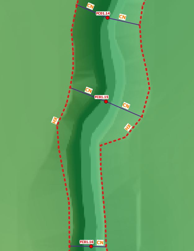
Depending on the water level in the surrounding 2D cells, flow can either enter or leave the HX cells. The volume of water entering or leaving the 2D boundary is added or subtracted from the 1D Flood Modeller model to preserve volume. The HX lines must be connected to the 1D Flood Modeller model. This is done using CN type lines in the 2d_bc layer, where a CN line is connected to the HX line, the water level from the 1D Flood Modeller nodes is transferred to the HX line. In between 1D nodes, a linear interpolation of water level is applied. This is shown in the figure below.

Once the water level in Flood Modeller exceeds the elevation in the boundary cell, water can enter or leave the model. Similar to a Flood Modeller lateral spill or lateral inflow, the discharge is distributed laterally along the length of the HX line. Note that it is the elevation of the HX boundary cell centres that determines when the spill starts to occur and not the cross section within Flood Modeller. If there is a levee or flood defence, it is important that we use breaklines in the model to ensure that the elevations of the 2D cells are consistent with the levee crest. The next four images show a section view of the 1D/2D link and how this may progress during a flood event.
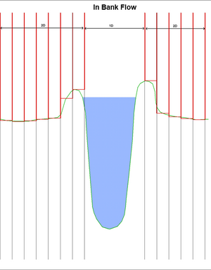
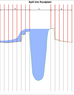
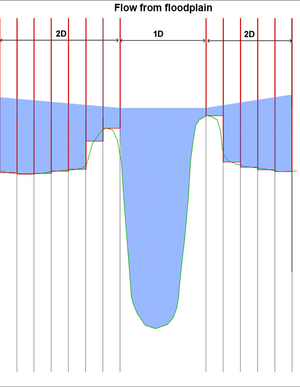
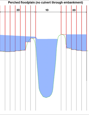
Often HX lines are located along the top of an embankment (natural or artificial) or flood defence running along the river bank. When carving a 1D channel through a 2D domain, the HX line must be either on the top of the embankment or on the inside of the embankment (closest to the channel). If the HX line is located on the other side of the embankment away from the channel, the effect of the embankment on water flow is not modelled. In the image above, it can be seen that the boundary cell is along the embankment and the interaction between the channel and the floodplain (1D and 2D) occurs at the correct elevation.
Building a Flood Modeller-TUFLOW 1D-2D HX Connection
Flood Modeller and TUFLOW will be considered linked if a Flood Modeller node in a 1d_x1D layer is snapped to a TUFLOW CN line which in turn is snapped to a TUFLOW HX line in a 2d_bc file. ‘CN’ or connection lines read the water level from Flood Modeller and transfers this to the HX line.
In the figure below, the water level is calculated in Flood Modeller at the nodes FC01.16, FC01.15 and FC01.14. These water levels are linearly interpolated along the lengths of the HX line on each of the left and right banks of the watercourse. When the water level exceeds the ZC elevation of the boundary cell, water is able to flow out onto the TUFLOW 2D floodplain.
The digitised direction of the HX and CN lines is not important. The CN lines however should be digitised approximately perpendicular to the direction of flow. Two CN lines are digitised for each node and snapped to the HX boundary lines along the left and right banks at vertices. Both CN and HX lines are digitised within the same 2d_bc file, on a basic approach, you only need to input the type attribute (either CN or HX). It is also recommended to input an f attribute value of 1 for CN lines for clarity, however if left at zero TUFLOW will by default change this value to 1. There are a range of Flags that can be used within the 2d_bc file, also D values to change elevations of the link cells and also A values to change the storage across the cells. Further information on these can be found within the TUFLOW Manual.
The HX boundary lines should be digitised along the top of each bank such that the width between the lines approximately correlates to the width of the 1D channel. This is important so as not to either over/under compensate flow area between the two solvers.
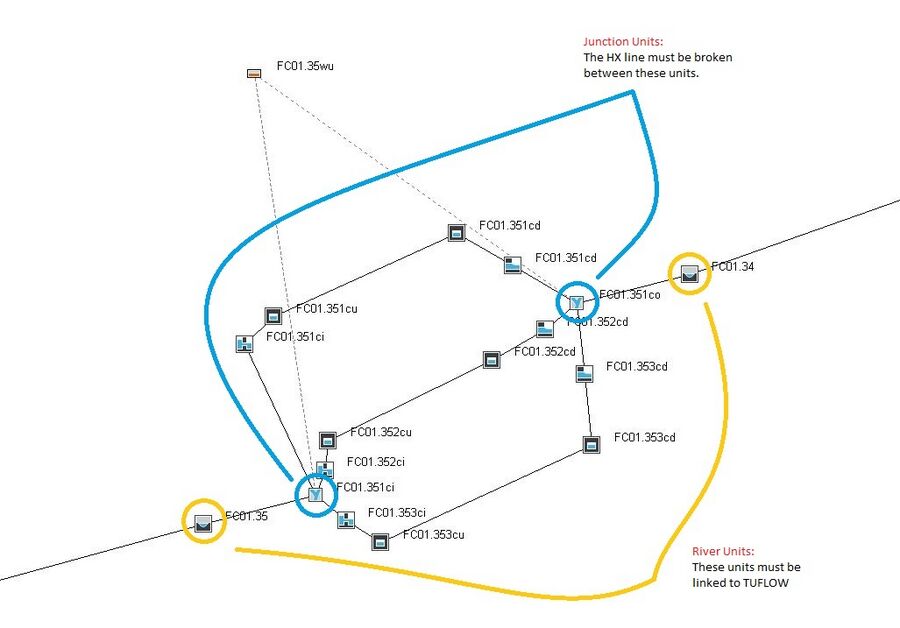
Note that where there are junctions within the Flood Modeller 1D model (i.e. at structures), both the nodes immediately upstream and downstream must be connected to TUFLOW. Refer to the below figure where the junctions are circled in blue and the upstream and downstream RIVER units are circled in yellow. The HX lines must be broken between the junctions as this is a requirement of a linked Flood Modeller – TUFLOW model.
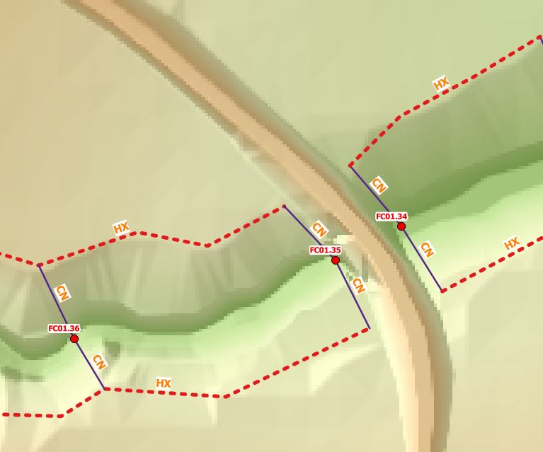
In the example below, the HX lines are broken between FC01.35 and FC01.34 as a culvert is located between these nodes.
Building a Flood Modeller-TUFLOW 1D-2D SX Connection
Flood Modeller can also be dynamically linked to outflow directly to the 2D TUFLOW domain at the start or end of a Flood Modeller reach. This can relate to tributary channels, small drainage channels, and also the main channel if exiting into a 2D estuarine environment for example.
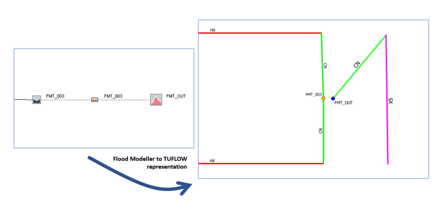
The image below shows the representation within Flood Modeller and TUFLOW of a simple flume model. As you can see in Flood Modeller, the end open channel section FMT_003 links directly to a spill unit, housing the same cross-section data, which then links to a dummy HT boundary unit. This dummy unit is left empty and works as a link between Flood Modeller and TUFLOW. To connect the Flood Modeller 1D network to TUFLOW, similar to the section above, the open channel section is linked via a 1D node and 2d_bc CN/HX connection. The SX link comes into play by having another 1D node (which, for clarity, it is recommended having a separate file to the Flood Modeller Nodes) which has the same ID as the dummy HT boundary. Remember that Flood Modeller is case sensitive so name exactly as is in Flood Modeller. As the connection between the open channel section FMT_003 and the dummy boundary happens in Flood Modeller, no literal link is needed between these in the TUFLOW GIS files. All that is needed otherwise is a 2d_bc file with a CN/SX link snapped to the dummy boundary node, this again can be in a separate file to the CN/HX links for clarity or can be in the same file.
Checking the Link
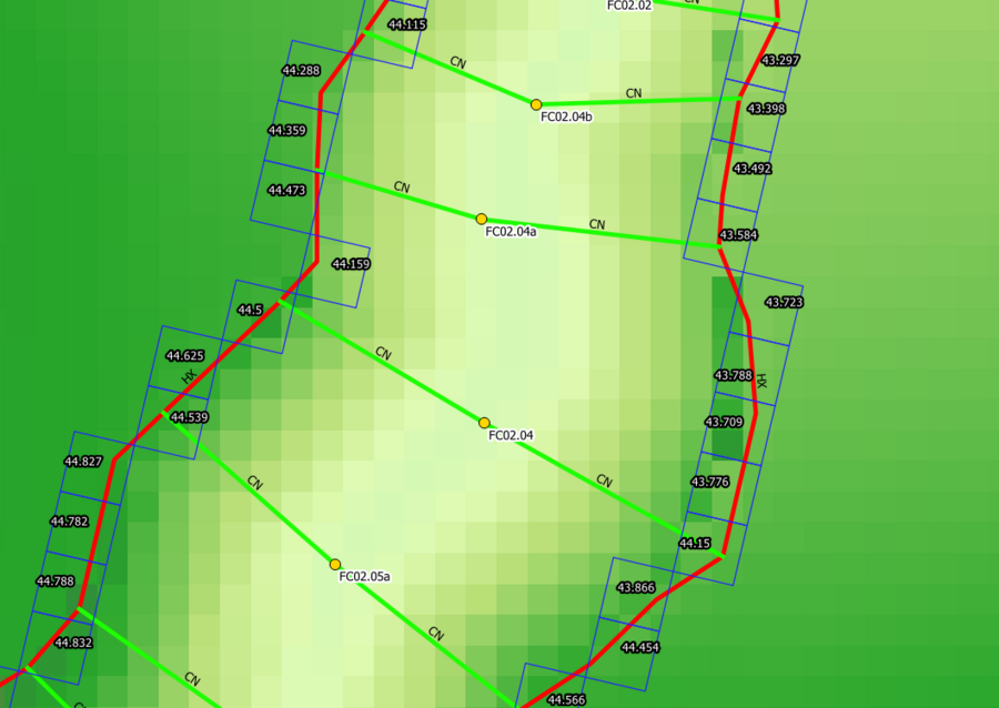
As with all aspects of TUFLOW modelling, checking your files are being applied as intended is important. The check file to use in the case of 1D 2D linking is of course the 1d_2d_check. In the image below you can see the channel being modelled and the Flood Modeller nodes connected via a CN/HX link discussed earlier. The 1d_2d_check file is shown by the blue grid cells. This shows the user the cells being picked up by the HX link lines, it also provides a wealth of information such as the primary Flood Modeller node it links to and if any flags where used in the HX lines for example. Below the image shows the elevation picked up at each link cell, which can be extremely useful in finding any abnormally low cells that have perhaps been incorrectly picked up and are subsequently leading to out of bank flow which wouldn't occur in reality.
Summary
1D Flood Modeller and 2D TUFLOW models can be dynamically coupled to enable a bi-directional connection between the two software using either HX or SX links. The linkage take place when an Flood Modeller node is snapped to a HX or SX boundary, this can be via a CN connection link. The dynamic coupling allows full integration between Flood Modeller 1D networks and full floodplain modelling in TUFLOW 2D to capture complex overland flows.
| Up |
|---|
