Check Files 2d grd: Difference between revisions
No edit summary |
No edit summary |
||
| (23 intermediate revisions by 4 users not shown) | |||
| Line 1: | Line 1: | ||
== Introduction == |
|||
This |
This page contains information on the _grd_check file. This file contains a region object for each active (cell code 1) or inactive (cell code -1) cell. A number of the output attributes are only written if certain model features are enabled. For example, the '''Soil_ID''' attribute is only included if any soil features are used in the model.<br> |
||
| ⚫ | |||
There are a number of attributes that are only output for TUFLOW GPU models, as the GPU model is a cell centred scheme certain properties such as Manning's roughness and Form Loss are applied at the cell centre, whilst in TUFLOW these are applied at the cell side (refer to the TUFLOW manual for a more detailed explanation). These GPU only attributes are noted in the table below. |
|||
There are variations in the output attributes for models using Sub-Grid Sampling (SGS) and/or Quadtree. These variations are noted below. <br> |
|||
| ⚫ | |||
| ⚫ | |||
=== General Attributes === |
|||
{| align="center" class="wikitable" width="75%" |
{| align="center" class="wikitable" width="75%" |
||
! style="background-color:#005581; font-weight:bold; color:white;"| Attribute Name |
! style="background-color:#005581; font-weight:bold; color:white;"| Attribute Name |
||
! style="background-color:#005581; font-weight:bold; color:white;" width=75%| Attribute Description |
! style="background-color:#005581; font-weight:bold; color:white;" width=75%| Attribute Description |
||
|- |
|- |
||
| n||Row number in the TUFLOW domain |
| n||Row number in the TUFLOW domain. |
||
|- |
|- |
||
| m||Column number in the TUFLOW domain |
| m||Column number in the TUFLOW domain. |
||
|- |
|- |
||
| Code||The cell code status. This is 1 for active cells and -1 for null cells that are included in the mesh. Refer to the TUFLOW Manual for more information on the cell codes. |
| Code||The cell code status. This is 1 for active cells and -1 for null cells that are included in the mesh. Refer to the <u>[https://docs.tuflow.com/classic-hpc/manual/latest/ TUFLOW Manual]</u> for more information on the cell codes. |
||
|- |
|- |
||
| Material||The material ID. |
| Material||The material ID. |
||
|- |
|- |
||
| ZC||The |
| ZC||The elevation within the cell. |
||
|- |
|- |
||
| IWL||The initial water level value. |
| IWL||The initial water level value. If the initial water level set in the model is below the cell elevation (ZC) or if no initial water level has been set, the cell elevation plus the model wet / dry depth is output. Note, this value is rounded to 3 decimal places. |
||
|- |
|- |
||
| Domain_Index||The index of the model domain. This is the order with <tt>Start 2D Domain == <Domain Name></tt> commands appears in the |
| Domain_Index||The index of the model domain. This is the order with <tt><font color="blue">Start 2D Domain</font><font color="red"> == </font><Domain Name></tt> commands appears in the TCF control file. For a single domain model this will be 1. |
||
|- |
|- |
||
| SRF ||The Storage Reduction Factor for the cell. |
|||
| Mann_n (GPU model only)||The Manning's n value for the cell. This is only output for a GPU model only as the GPU model is a cell centred scheme and the Manning's n value is applied at the cell centre. For a TUFLOW "classic" simulation the Manning's is applied at the cell side and this is output in the [[Check_Files_2d_uvpt | _uvpt_check.mif<br>_uvpt_check_P.shp]] |
|||
|- |
|- |
||
| Soil_ID (only if soil feature used)||The Soil ID for the cell. This is only output if a <font color="blue"><tt>Set Soil</tt></font>, <font color="blue"><tt>Read GIS Soil</tt></font> or <font color="blue"><tt>Read GRID Soil</tt></font> command is specified for the simulation. |
|||
| FLC (GPU model only)||Form loss coefficient, this is only output for a GPU model only as the GPU model is a cell centred scheme and the FLC value is applied at the cell centre. For a TUFLOW "classic" simulation this is applied at the cell side and this is output in the [[Check_Files_2d_uvpt | _uvpt_check.mif<br>_uvpt_check_P.shp]] |
|||
|- |
|- |
||
| GW_Z_L1 (only if soils are used)||The groundwater level for each cell. This is equal to the elevation in the cell minus the soil thickness. If no soil thickness is specified (using the <tt><font color="blue">Set Soil Thickness</font></tt> TGC command), the attribute will be set to -99999. This attribute is only output if using soils, i.e. if the <font color="blue"><tt>Set Soil</tt></font>, <font color="blue"><tt>Read GIS Soil</tt></font> and/or <font color="blue"><tt>Read Grid Soil</tt></font> TGC command(s) have been used. |
|||
| CWF_x (GPU model only)||Cell width factor in the x-direction. This is only output for a GPU model only as the GPU model is a cell centred scheme and the CWF value is applied at the cell centre. For a TUFLOW "classic" simulation this is applied at the cell side and this is output in the [[Check_Files_2d_uvpt | _uvpt_check.mif<br>_uvpt_check_P.shp]] |
|||
|- |
|- |
||
| IGW_Lvl_L1 (only if soils are used)||The initial groundwater level for each cell. This is equal to the elevation in the cell minus the initial groundwater depth. If no initial groundwater depth is specified (using the <tt><font color="blue">Set IGW Depth</font></tt> TGC command), the attribute will be set to the GW_Z_L1 value. This attribute is only output if using soils, i.e. if the <font color="blue"><tt>Set Soil</tt></font>, <font color="blue"><tt>Read GIS Soil</tt></font> and/or <font color="blue"><tt>Read Grid Soil</tt></font> TGC command(s) have been used. |
|||
| CWF_y (GPU model only)||Cell width factor in the y-direction. This is only output for a GPU model only as the GPU model is a cell centred scheme and the CWF value is applied at the cell centre. For a TUFLOW "classic" simulation this is applied at the cell side and this is output in the [[Check_Files_2d_uvpt | _uvpt_check.mif<br>_uvpt_check_P.shp]] |
|||
|} |
|||
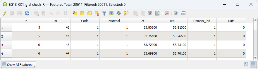
:'''Example _grd_check attribute table:''' |
|||
:[[File: 2d_grd_Reg_attribute_table_01.png]] |
|||
=== SGS Specific Attributes === |
|||
{| align="center" class="wikitable" width="75%" |
|||
! style="background-color:#005581; font-weight:bold; color:white;"| Attribute Name |
|||
! style="background-color:#005581; font-weight:bold; color:white;" width=75%| Attribute Description |
|||
|- |
|- |
||
| |
| ZMin||The minimum elevation within the cell. |
||
|- |
|- |
||
| |
| Z_Map_Cutoff||The map output cutoff elevation for each cell. This is equal to the minimum cell elevation plus the map cutoff depth (specified by the TCF command <tt><font color="blue">Map Cutoff Depth</font></tt>). |
||
|- |
|||
| SGS_Delta||This attribute is output only if the <font color="blue"><tt>SGS Breakline Detection Delta</tt></font> TCF command has been used. The SGS breakline detection check processes each 2D cell to identify the minimum water surface elevation needed for a continuous wet connection through the cell traversing between left to right and between top to bottom. The maximum invert elevation of the left and right faces is subtracted from the left-right minimum water level and reports it as “uDelta”. Similarly, the top to bottom value is reported as “vDelta”. uDelta and vDelta represent the depth of water over the cell face inverts by which a natural ridge (break) line would block any flow. This attribute reports the maximum of uDelta and vDelta. |
|||
|} |
|} |
||
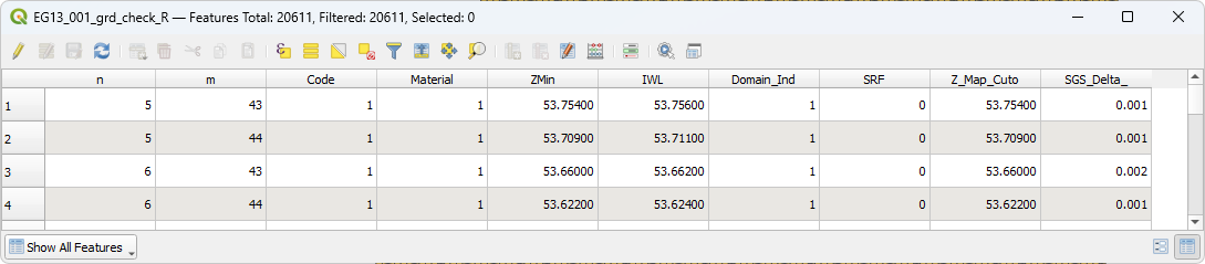
:'''Example _grd_check attribute table (using SGS):'''<br> |
|||
:[[File: 2d_grd_SGS_attribute_table_01.png]] |
|||
| ⚫ | |||
=== Quadtree Specific Attributes === |
|||
This allows a very easy way to visualise the final properties for large models. |
|||
{| align="center" class="wikitable" width="75%" |
|||
! style="background-color:#005581; font-weight:bold; color:white;"| Attribute Name |
|||
! style="background-color:#005581; font-weight:bold; color:white;" width=75%| Attribute Description |
|||
|- |
|||
| qpc_id||The quadtree cell ID. |
|||
|- |
|||
| dx||The size of the cell. This value is dependent on the base cell size and the quadtree nesting level. For example, for a base cell size of 5m and nesting level 2, the dx attribute would be 2.5m. |
|||
|} |
|||
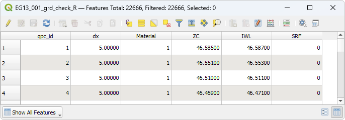
:'''Example _grd_check attribute table (using Quadtree):'''<br> |
|||
:[[File: 2d_grd_Quad_attribute_table_01.png]] |
|||
| ⚫ | |||
== Features == |
|||
| ⚫ | |||
<br><br> |
<br><br> |
||
A _grd_check file styled by material ID is shown below.<br> |
|||
| ⚫ | |||
[[ File:Grd check SoilID1.JPG]] |
|||
[[File:2d_grd_check_01a.png]]<br> |
|||
| ⚫ | |||
<br> |
|||
An example of a grid check file shaded by Material ID is below (in MapInfo).<br> |
|||
A _grd_check file for a Quadtree model is shown below. It has been styled with the default TUFLOW styling.<br> |
|||
[[File:MI thematic map 04.jpg]] |
|||
<br> |
|||
[[File:2d_grd_check_02a.png]]<br> |
|||
<br> |
|||
{{Tips Navigation |
|||
|uplink=[[TUFLOW_Check_Files | TUFLOW Check Files]] |
|||
}} |
|||
Latest revision as of 15:43, 5 August 2025
Introduction
This page contains information on the _grd_check file. This file contains a region object for each active (cell code 1) or inactive (cell code -1) cell. A number of the output attributes are only written if certain model features are enabled. For example, the Soil_ID attribute is only included if any soil features are used in the model.
There are variations in the output attributes for models using Sub-Grid Sampling (SGS) and/or Quadtree. These variations are noted below.
Attributes of grd_check
General Attributes
| Attribute Name | Attribute Description |
|---|---|
| n | Row number in the TUFLOW domain. |
| m | Column number in the TUFLOW domain. |
| Code | The cell code status. This is 1 for active cells and -1 for null cells that are included in the mesh. Refer to the TUFLOW Manual for more information on the cell codes. |
| Material | The material ID. |
| ZC | The elevation within the cell. |
| IWL | The initial water level value. If the initial water level set in the model is below the cell elevation (ZC) or if no initial water level has been set, the cell elevation plus the model wet / dry depth is output. Note, this value is rounded to 3 decimal places. |
| Domain_Index | The index of the model domain. This is the order with Start 2D Domain == <Domain Name> commands appears in the TCF control file. For a single domain model this will be 1. |
| SRF | The Storage Reduction Factor for the cell. |
| Soil_ID (only if soil feature used) | The Soil ID for the cell. This is only output if a Set Soil, Read GIS Soil or Read GRID Soil command is specified for the simulation. |
| GW_Z_L1 (only if soils are used) | The groundwater level for each cell. This is equal to the elevation in the cell minus the soil thickness. If no soil thickness is specified (using the Set Soil Thickness TGC command), the attribute will be set to -99999. This attribute is only output if using soils, i.e. if the Set Soil, Read GIS Soil and/or Read Grid Soil TGC command(s) have been used. |
| IGW_Lvl_L1 (only if soils are used) | The initial groundwater level for each cell. This is equal to the elevation in the cell minus the initial groundwater depth. If no initial groundwater depth is specified (using the Set IGW Depth TGC command), the attribute will be set to the GW_Z_L1 value. This attribute is only output if using soils, i.e. if the Set Soil, Read GIS Soil and/or Read Grid Soil TGC command(s) have been used. |
- Example _grd_check attribute table:

SGS Specific Attributes
| Attribute Name | Attribute Description |
|---|---|
| ZMin | The minimum elevation within the cell. |
| Z_Map_Cutoff | The map output cutoff elevation for each cell. This is equal to the minimum cell elevation plus the map cutoff depth (specified by the TCF command Map Cutoff Depth). |
| SGS_Delta | This attribute is output only if the SGS Breakline Detection Delta TCF command has been used. The SGS breakline detection check processes each 2D cell to identify the minimum water surface elevation needed for a continuous wet connection through the cell traversing between left to right and between top to bottom. The maximum invert elevation of the left and right faces is subtracted from the left-right minimum water level and reports it as “uDelta”. Similarly, the top to bottom value is reported as “vDelta”. uDelta and vDelta represent the depth of water over the cell face inverts by which a natural ridge (break) line would block any flow. This attribute reports the maximum of uDelta and vDelta. |
- Example _grd_check attribute table (using SGS):

Quadtree Specific Attributes
| Attribute Name | Attribute Description |
|---|---|
| qpc_id | The quadtree cell ID. |
| dx | The size of the cell. This value is dependent on the base cell size and the quadtree nesting level. For example, for a base cell size of 5m and nesting level 2, the dx attribute would be 2.5m. |
- Example _grd_check attribute table (using Quadtree):

Features
This file is very useful to apply a style or thematic map to and it helps for visualising the final properties for large models.
A _grd_check file styled by material ID is shown below.

A _grd_check file for a Quadtree model is shown below. It has been styled with the default TUFLOW styling.

| Up |
|---|