ARR DATAHUB CANNOT BE ACCESSED: Difference between revisions
Jump to navigation
Jump to search
Content deleted Content added
Ellis Symons (talk | contribs) No edit summary |
Ellis Symons (talk | contribs) No edit summary |
||
| Line 4: | Line 4: | ||
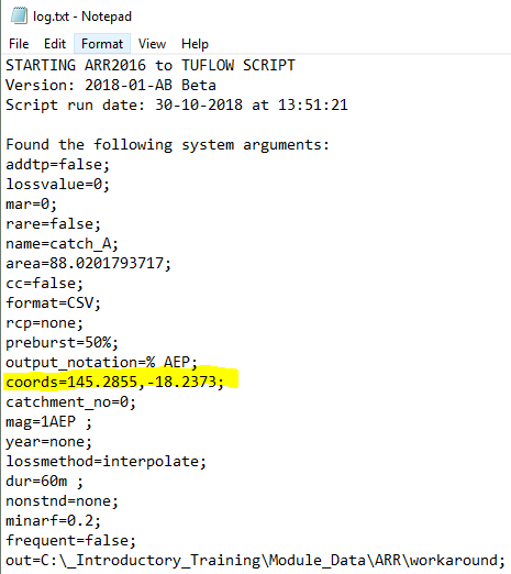
<li> Open 'log.txt' and extract the longitudinal and latitude values<br>[[File:log_text_coords.PNG]] |
<li> Open 'log.txt' and extract the longitudinal and latitude values<br>[[File:log_text_coords.PNG]] |
||
<li> Using an internet browser, navigate to the [http://data.arr-software.org/ ARR datahub] |
<li> Using an internet browser, navigate to the [http://data.arr-software.org/ ARR datahub] |
||
<li> Input the coordinates of your catchment |
|||
<li> Tick on the 'Select All' box |
|||
<li> Click '''Submit''' |
|||
Revision as of 14:56, 30 October 2018
Steps
- Run 'Extract ARR2016 for TUFLOW' tool in QGIS until error - This will let the tool download the data from BOM as well as perform the pre-calculations such as extract the catchment area and centroid from the input catchments
- Open 'log.txt' and extract the longitudinal and latitude values
- Using an internet browser, navigate to the ARR datahub
- Input the coordinates of your catchment
- Tick on the 'Select All' box
- Click Submit
