ARR DATAHUB CANNOT BE ACCESSED: Difference between revisions
Ellis Symons (talk | contribs) No edit summary |
Ellis Symons (talk | contribs) No edit summary |
||
| Line 6: | Line 6: | ||
There is a workaround in place for this situation. It requires the user to manually extract data from the ARR datahub, perform some file manipulation, then save the file in the correct location with the correct name. The tool has been setup to first attempt to access the ARR datahub. If failing this, it will then seek to find an existing copy of the extracted data.<br> |
There is a workaround in place for this situation. It requires the user to manually extract data from the ARR datahub, perform some file manipulation, then save the file in the correct location with the correct name. The tool has been setup to first attempt to access the ARR datahub. If failing this, it will then seek to find an existing copy of the extracted data.<br> |
||
=Steps= |
=Steps= |
||
The following steps describe how to manually extract data from the ARR datahub and format appropriately for the tool to use. The first 2 steps are not necessary if the user knows the longitude and latitude of the location they would like to extract information for. |
|||
<ol> |
<ol> |
||
<li> Run 'Extract ARR2016 for TUFLOW' tool in QGIS until error - ''This will let the tool |
<li> Run 'Extract ARR2016 for TUFLOW' tool in QGIS until error - ''This will let the tool perform the pre-calculations such as extract the catchment area and centroid from the input catchments'' |
||
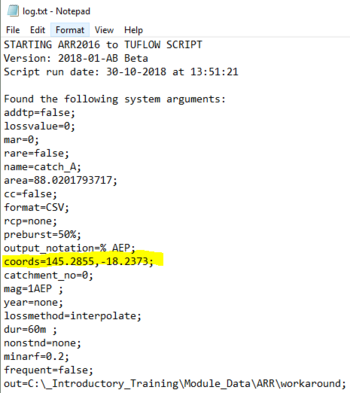
<li> Open 'log.txt' located in the tool output folder and extract the longitudinal and latitude values<br>[[File:log_text_coords.PNG | 350px]] |
<li> Open 'log.txt' located in the tool output folder and extract the longitudinal and latitude values<br>[[File:log_text_coords.PNG | 350px]] |
||
<li> Using an internet browser, navigate to the [http://data.arr-software.org/ ARR datahub] |
<li> Using an internet browser, navigate to the [http://data.arr-software.org/ ARR datahub] |
||
Revision as of 16:13, 30 October 2018
Purpose
This page has been setup in the event that the ARR datahub cannot be accessed by 'Extract ARR2016 for TUFLOW' tool in QGIS, but can still be accessed manually by the user. This situation may occur during times of heavy automated traffic on the website.
The following error appears in the log.txt when the tool cannot access the ARR website.
Failed to get data from ARR website
Workaround
There is a workaround in place for this situation. It requires the user to manually extract data from the ARR datahub, perform some file manipulation, then save the file in the correct location with the correct name. The tool has been setup to first attempt to access the ARR datahub. If failing this, it will then seek to find an existing copy of the extracted data.
Steps
The following steps describe how to manually extract data from the ARR datahub and format appropriately for the tool to use. The first 2 steps are not necessary if the user knows the longitude and latitude of the location they would like to extract information for.
- Run 'Extract ARR2016 for TUFLOW' tool in QGIS until error - This will let the tool perform the pre-calculations such as extract the catchment area and centroid from the input catchments
- Open 'log.txt' located in the tool output folder and extract the longitudinal and latitude values
- Using an internet browser, navigate to the ARR datahub
- Input the coordinates of your catchment
- Tick on the 'Select All' box
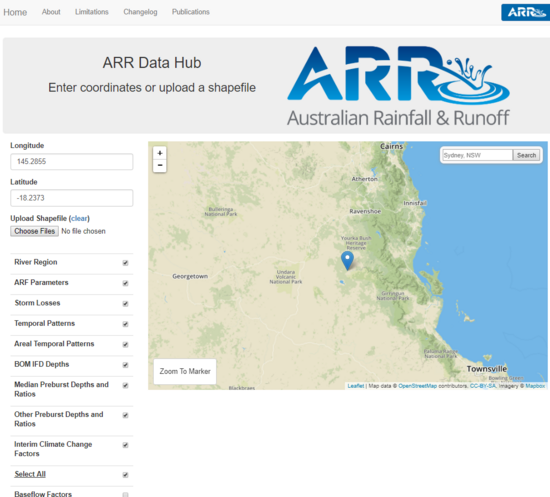
- Click Submit
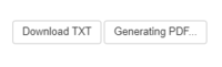
- Navigate to the bottom of the page and click Download TXT
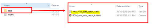
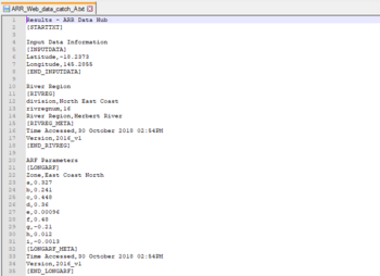
- Create a new .txt file called 'ARR_Web_Data_<catchment name>.txt' and save it in the data folder alongside the existing file 'BOM_raw_web_<catchment name>.html - The catchment name should be consistent with the name used in the QGIS tool. It will be the same as the BOM raw output and also be listed in the log.txt after name=
- Copy the text from the 'Download TXT to the newly created 'ARR_web_data' text file
- On the ARR datahub page, navigate to the temporal patterns and click Download (.zip)
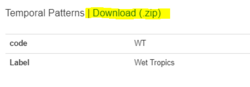
- Extract the contents of the zip file
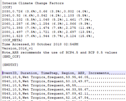
- Open '_increments.csv' in a text editor
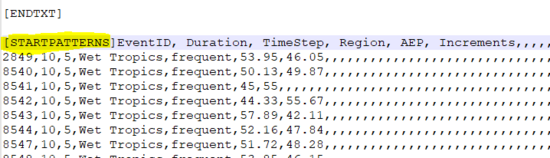
- Copy the contents of the csv to the end of 'ARR_Web_data'
- Infront of 'EventID' in the newly copied across data, insert the following text [STARTPATTERNS]
- Save 'ARR_web_data_'
- Run the tool in QGIS again - The tool should now first try and access the datahub online. If this fails, it will then look for a pre-existing datahub output with temporal patterns included


