Tutorial M06 002 Results QGIS: Difference between revisions
Jump to navigation
Jump to search
Content deleted Content added
No edit summary |
|||
| Line 1: | Line 1: | ||
= |
=Introduction= |
||
QGIS is used to view the cumulative rainfall, rainfall rate and material rainfall losses with the TUFLOW Viewer. For viewing of the 2D map results, see <u>[[Draft_viewing_results_M01 | Module 1]]</u>.<br> |
|||
QGIS is used to create, import and view input data.<br> |
|||
<br> |
<br> |
||
= |
=Method= |
||
Inspect cumulative rainfall, rainfall rate and loss outputs: |
|||
Create a 2d_rf layer with digitised polygons based on the input rainfall hyetographs: |
|||
<ol> |
<ol> |
||
<li> |
<li>Open the TUFLOW Viewer. |
||
<li>Select File > Load Results. Navigate to the '''M06_5m_002.tcf''' in the '''Module_06\TUFLOW\runs''' folder and open it. |
|||
<li>Select '2d_rf' from the Empty Type list. |
|||
<li>One additional output type appears in the Result Type panel: |
|||
<li>In the Run ID box write: 'M06_polygons_002'. |
|||
:*Cum. Mat. Loss: the total rainfall losses applied as initial and continuing losses specified in the materials file. |
|||
<li>Tick the 'Regions' Geometry Type and hit 'OK'. The 2d_rf appears in the QGIS Layers panel.<br> |
|||
<li>Use the Plot Time Series tool to see the cumulative material loss time series. Notice the variation due to the assigned materials ID:<br> |
|||
</ol> |
|||
The same catchment breakup is used as the 2d_sa layer: |
|||
<ol><li>Navigate to the '''Module_06\TUFLOW\model\gis''' folder and open the '''2d_sa_M01_001_R.shp''' layer in QGIS. |
|||
<li>Copy and paste the polygons from the 2d_sa layer into the 2d_rf: <br> |
|||
<br> |
<br> |
||
[[File:Animation M06 |
[[File:Animation M06 Results 002 01.gif]]<br> |
||
<br> |
<br> |
||
<li>Use the Plot Time Series tool to see the time series of the cumulative rainfall, rainfall rate and losses at a point. Notice the results vary spatially due to the 2d_rf polygons and 2d_mat regions: <br> |
|||
<li>Open the attribute table and make the following edits: |
|||
:*Update names to match the names in the '''rainfall_station.csv''' input data (RF_FC04, RF_FC05, RF_FC06, RF_FC07) |
|||
:*f1: 1 |
|||
:*f2: 1 <br> |
|||
The attributes f1 and f2 are multipliers adjusting the rainfall spatially. No adjustments are made, a value of 1, e.g. 100% of specified rainfall is used. <br> |
|||
<li>Turn off editing to save the edits.<br> |
|||
<br> |
<br> |
||
[[File:Animation M06 |
[[File:Animation M06 Results 002 02.gif]]<br> |
||
| ⚫ | |||
</ol> |
</ol> |
||
| ⚫ | |||
=Conclusion= |
=Conclusion= |
||
:*The cumulative rainfall, rainfall rate and rainfall material losses derived from rainfall polygons were inspected with the TUFLOW Viewer.<br> |
|||
:*Polygons have been digitised based on input rainfall hyetographs. |
|||
| ⚫ | |||
| ⚫ | |||
{{Tips Navigation |
{{Tips Navigation |
||
|uplink=[[Tutorial_M06#Results_2| Back to Module 6 Main Page]] |
|uplink=[[Tutorial_M06#Results_2| Back to Module 6 Main Page]] |
||
Revision as of 02:51, 10 May 2022
Introduction
QGIS is used to view the cumulative rainfall, rainfall rate and material rainfall losses with the TUFLOW Viewer. For viewing of the 2D map results, see Module 1.
Method
Inspect cumulative rainfall, rainfall rate and loss outputs:
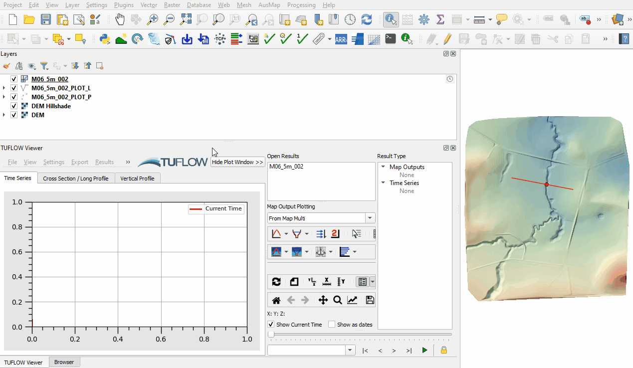
- Open the TUFLOW Viewer.
- Select File > Load Results. Navigate to the M06_5m_002.tcf in the Module_06\TUFLOW\runs folder and open it.
- One additional output type appears in the Result Type panel:
- Cum. Mat. Loss: the total rainfall losses applied as initial and continuing losses specified in the materials file.
- Use the Plot Time Series tool to see the cumulative material loss time series. Notice the variation due to the assigned materials ID:

- Use the Plot Time Series tool to see the time series of the cumulative rainfall, rainfall rate and losses at a point. Notice the results vary spatially due to the 2d_rf polygons and 2d_mat regions:


Conclusion
- The cumulative rainfall, rainfall rate and rainfall material losses derived from rainfall polygons were inspected with the TUFLOW Viewer.
- The cumulative rainfall, rainfall rate and rainfall material losses derived from rainfall polygons were inspected with the TUFLOW Viewer.
| Up |
|---|