FM Tute M01 QGIS 1D2D Code: Difference between revisions
Jump to navigation
Jump to search
Content deleted Content added
Andrew.Sims (talk | contribs) No edit summary |
Andrew.Sims (talk | contribs) No edit summary |
||
| Line 9: | Line 9: | ||
<li> For all polygons assign a 'type' attribute of 'CD'. A 2D BC type of 'CD' designates the digitised polygon as a code polygon. </li> |
<li> For all polygons assign a 'type' attribute of 'CD'. A 2D BC type of 'CD' designates the digitised polygon as a code polygon. </li> |
||
<li> For all polygons assign a 'f' attribute of '-1'. A cell code of '-1' deactivates all cells within the digitised code polygons. </li> |
<li> For all polygons assign a 'f' attribute of '-1'. A cell code of '-1' deactivates all cells within the digitised code polygons. </li> |
||
[[File:FMT QGIS 1D2D Code attribute.JPG|600px]] |
|||
<li> Observe how the code polygon has been digitised between FC01.35 and FC01.34. The polygon covers the area between these two Flood Modeller nodes. This is because overtopping of the embankmentat this location has been represented in the 1D Flood Modeller component of the model.</li> |
<li> Observe how the code polygon has been digitised between FC01.35 and FC01.34. The polygon covers the area between these two Flood Modeller nodes. This is because overtopping of the embankmentat this location has been represented in the 1D Flood Modeller component of the model.</li> |
||
[[File:FMT QGIS 1D2D Code Polygon digitisation.JPG|600px]] |
[[File:FMT QGIS 1D2D Code Polygon digitisation.JPG|600px]] |
||
Revision as of 01:22, 25 October 2016
- Import in an empty 2d_bc_empty_r. shp layer from within the TUFLOW\model\gis\empty folder and save as 2d_bc_hxi_FMT_001_R.shp.
- Open the Inactive_area.shp GIS layer from Module_Data\Module_01\gis folder. Select all objects from within this layer, copy and paste into 2d_bc_hxi_FMT_001_R.shp.
- For all polygons assign a 'type' attribute of 'CD'. A 2D BC type of 'CD' designates the digitised polygon as a code polygon.
- For all polygons assign a 'f' attribute of '-1'. A cell code of '-1' deactivates all cells within the digitised code polygons.
- Observe how the code polygon has been digitised between FC01.35 and FC01.34. The polygon covers the area between these two Flood Modeller nodes. This is because overtopping of the embankmentat this location has been represented in the 1D Flood Modeller component of the model. File:FMT QGIS 1D2D Code Polygon digitisation.JPG
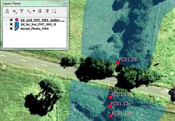
- Observe how the code polygon has been digitised downstream of FC01.11. In this case, no code polygon has been defined over the embankment. This is because overtopping of the embankment will be modelled in the 2D TUFLOW component of the model. This is why there are additional HX boundary polylines at the upstream and downstream faces of the embankment.
- Save the file in preparation for reading in TUFLOW. Please return to the Flood Modeller Tutorial Model module 1 page here.
Introduction
In this section we will deactivate the 2D cells where the 1D Flood Modeller component is replacing the 2D solution. The deactivated 2D area should be the same as the area modelled in 1D. This is to ensure that the storage removed from the 2D component of the model is equal to the storage modelled in the 1D component of the model.
Method

