QGIS OpenLayers: Difference between revisions
Jump to navigation
Jump to search
Content deleted Content added
Created page with "=OpenLayers= OpenLayers is a plugin that can be added to QGIS, this plugin allows Google, Bing and Yahoo layers to be added. To install the plugin, select ''Plugins >> Fetch Py..." |
Chris Huxley (talk | contribs) No edit summary |
||
| Line 1: | Line 1: | ||
Aerial imagery can be added using core XYZ Tile Server functionality (implemented in 2018): |
|||
=OpenLayers= |
|||
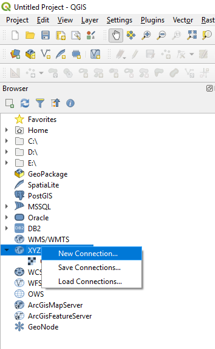
* Locate the Tile Server entry and right click it to add a new service. |
|||
OpenLayers is a plugin that can be added to QGIS, this plugin allows Google, Bing and Yahoo layers to be added. |
|||
[[File:QGIS_Aerial_001.png|400px]] <br> |
|||
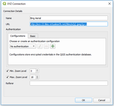
* Enter the URL of the service which you would like to use. Example URLs are listed at he bottom of this page. |
|||
[[File:QGIS_Aerial_002.png|400px]] <br> |
|||
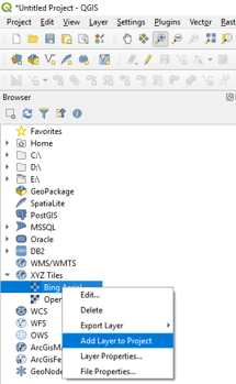
* Open aerial imagery by right clicking the relevant service link and selecting Add Layer to Project. |
|||
[[File:QGIS_Aerial_003.png|400px]] <br> |
|||
OpenStreetMap: |
|||
To install the plugin, select ''Plugins >> Fetch Python Plugins'', type OpenLayers into the filter and install plugin. |
|||
http://tile.openstreetmap.org/{z}/{x}/{y}.png |
|||
Bing Aerial |
|||
Once installed, to access the plugin, simply select ''Plugins >> OpenLayers Plugin'' and select the layer you wish to add. |
|||
http://ecn.t3.tiles.virtualearth.net/tiles/a{q}.jpeg?g=1 |
|||
Google Hybrid |
|||
[[File:QGIS OpenLayers 01.png|frame|none]] |
|||
https://mt1.google.com/vt/lyrs=y&x={x}&y={y}&z={z} |
|||
Google Satellite |
|||
The layer should then appear in the map window. If the layer is displaying incorrectly, check the projection of the project is correct, this is the under CRS tab of the ''Settings >> Project Properties'' dialogue. |
|||
https://mt1.google.com/vt/lyrs=s&x={x}&y={y}&z={z} |
|||
Google Road |
|||
[[File:QGIS OpenLayers 02.png|frame|none]] |
|||
https://mt1.google.com/vt/lyrs=m&x={x}&y={y}&z={z} |
|||
Revision as of 05:57, 26 February 2019
Aerial imagery can be added using core XYZ Tile Server functionality (implemented in 2018):
- Locate the Tile Server entry and right click it to add a new service.
- Enter the URL of the service which you would like to use. Example URLs are listed at he bottom of this page.
- Open aerial imagery by right clicking the relevant service link and selecting Add Layer to Project.
 OpenStreetMap:
 http://tile.openstreetmap.org/{z}/{x}/{y}.png
 Bing Aerial
 http://ecn.t3.tiles.virtualearth.net/tiles/a{q}.jpeg?g=1
 Google Hybrid
 https://mt1.google.com/vt/lyrs=y&x={x}&y={y}&z={z}
 Google Satellite
 https://mt1.google.com/vt/lyrs=s&x={x}&y={y}&z={z}
 Google Road
 https://mt1.google.com/vt/lyrs=m&x={x}&y={y}&z={z}


