TUFLOW Rainfall Control File Examples: Difference between revisions
| Line 30: | Line 30: | ||
<br> |
<br> |
||
For each of the interpolation method the total rainfall depth is shown. The colouring is the same for all of these grids, with the legend shown below.<br> |
For each of the interpolation method the total rainfall depth is shown. The colouring is the same for all of these grids, with the legend shown below.<br> |
||
[[File:TRFCF Legend.jpg| |
[[File:TRFCF Legend.jpg|150px]] |
||
=IDW= |
=IDW= |
||
Revision as of 11:01, 14 January 2021
Introduction
This page contains some simple rainfall control file examples.
The Rainfall Control file is referenced in the tcf by the command:
Rainfall Control File == <filename>
The model setup is a very simple square model, with a series of rainfall points within or close to the model area, as shown in the image below. The dashed outline is the TUFLOW model area and the labelled points are the 2d_rf point locations which are labelled by the "Name" attribute.
The purpose of the model is only to demonstrate the point rainfall to gridded rainfall functionality. The rainfall and locations are 100% made up!
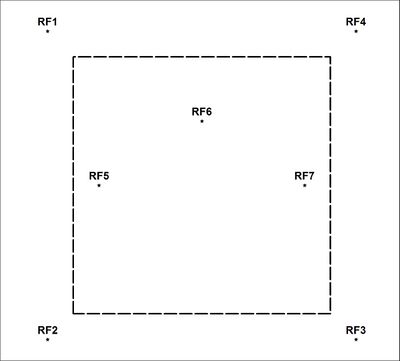
The provided rainfall control files, use the same temporal pattern but different depths of rainfall. For the points listed above the rainfall depths are outlined in the tabel below:
Total Rainfall Depths
| Boundary Name | Total Rainfall Depth (mm) |
|---|---|
| RF1 | 30 |
| RF2 | 60 |
| RF3 | 90 |
| RF4 | 120 |
| RF5 | 150 |
| RF6 | 180 |
| RF7 | 210 |
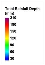
For each of the interpolation method the total rainfall depth is shown. The colouring is the same for all of these grids, with the legend shown below.
IDW
RF Grid Cell Size == 5 ! sets the output rainfall grid cell size
RF Grid Format == nc ! output in netcdf format
Read GIS RF Points == ..\model\mi\2d_rf_pts_001.MIF
RF Interpolation Method == IDW
IDW Exponent == 2
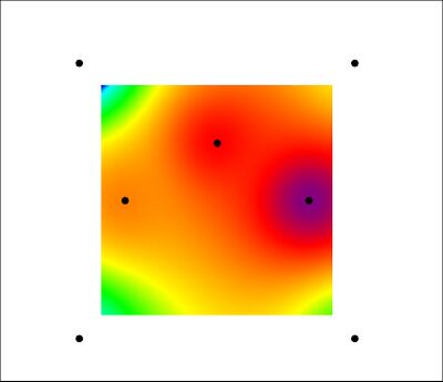
The total rainfall depth is shown above for the IDW method, the rainfall points are shown as black dots.
TIN
RF Grid Cell Size == 5 ! sets the output rainfall grid cell size
RF Grid Format == nc ! output in netcdf format
Read GIS RF Points == ..\model\mi\2d_rf_pts_001.MIF
RF Interpolation Method == TIN
Read GIS RF Triangle == ..\model\mi\2d_RF_TIN_001.MIF ! GIS layer containing series of triangular polygons
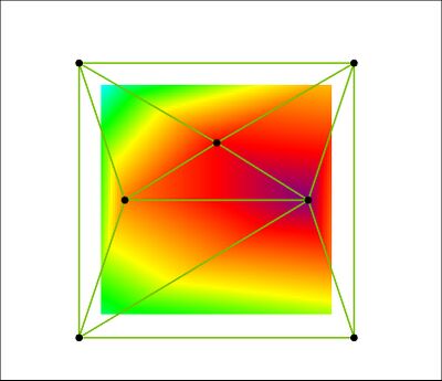
The total rainfall depth is shown above for the IDW method, the rainfall points are shown as black dots and the triangles for the TIN interpolation are shown with a green outline.
Poly
Maximum RF Locations == 20 ! Sets the maximum number of rainfall point location
Maximum Hyetograph Points == 100 ! Sets the maximum number of points in the rainfall hyetograph
RF Grid Cell Size == 5 ! sets the output rainfall grid cell size
RF Grid Format == asc ! output as series of ESRI ascii format grids
Read GIS RF Points == ..\model\mi\2d_rf_pts_001.MIF
RF Interpolation Method == Poly
Read GIS RF Polygon == ..\model\mi\2d_RF_Poly_001.MIF
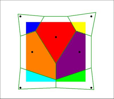
The total rainfall depth is shown above for the polygon method, the rainfall points are shown as black dots and the rainfall polygons are shown with a green outline.