QGIS TUFLOW Arch Bridge Editor: Difference between revisions
Jump to navigation
Jump to search
Content deleted Content added
Ellis Symons (talk | contribs) No edit summary |
Ellis Symons (talk | contribs) No edit summary |
||
| Line 6: | Line 6: | ||
<ol> |
<ol> |
||
<li> '''GIS Inputs''' |
<li> '''GIS Inputs''' |
||
: 1d_nwk and 1d_xs inputs. The 1d_nwk layer and the bridge feature must already exist. It is not required that the arch bridge attributes are filled out, however the spatial geometry should be represented already (i.e. the polyline must already be drawn).<br> |
:* 1d_nwk and 1d_xs inputs. The 1d_nwk layer and the bridge feature must already exist. It is not required that the arch bridge attributes are filled out, however the spatial geometry should be represented already (i.e. the polyline must already be drawn).<br> |
||
: The 1d_nwk layer should be selected in the first dropdown box, and the arch bridge feature in the second dropdown box. The arch bridge can be selected within the map window using the selection tool [[File: arch_bridge_feature_selection_button.PNG]] (from within the arch bridge editor dock, not the standard QGIS tool). The 1d_xs layer will be created if "-None-" is selected within the third dropdown box. The tool will automatically find any 1d_xs features intersecting the bridge polyline if a 1d_xs layer is selected.<br> |
:* The 1d_nwk layer should be selected in the first dropdown box, and the arch bridge feature in the second dropdown box. The arch bridge can be selected within the map window using the selection tool [[File: arch_bridge_feature_selection_button.PNG]] (from within the arch bridge editor dock, not the standard QGIS tool). The 1d_xs layer will be created if "-None-" is selected within the third dropdown box. The tool will automatically find any 1d_xs features intersecting the bridge polyline if a 1d_xs layer is selected.<br> |
||
: The text below the GIS inputs will provide the status on the GIS inputs e.g. Whether the tool has found any 1d_xs intersecting the arch bridge polylline. |
:* The text below the GIS inputs will provide the status on the GIS inputs e.g. Whether the tool has found any 1d_xs intersecting the arch bridge polylline. |
||
</ol> |
</ol> |
||
Revision as of 12:38, 29 November 2022
This Page is Currently Under Construction
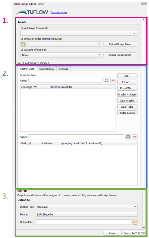
The Interface
- GIS Inputs
- 1d_nwk and 1d_xs inputs. The 1d_nwk layer and the bridge feature must already exist. It is not required that the arch bridge attributes are filled out, however the spatial geometry should be represented already (i.e. the polyline must already be drawn).
- The 1d_nwk layer should be selected in the first dropdown box, and the arch bridge feature in the second dropdown box. The arch bridge can be selected within the map window using the selection tool
(from within the arch bridge editor dock, not the standard QGIS tool). The 1d_xs layer will be created if "-None-" is selected within the third dropdown box. The tool will automatically find any 1d_xs features intersecting the bridge polyline if a 1d_xs layer is selected.
- The text below the GIS inputs will provide the status on the GIS inputs e.g. Whether the tool has found any 1d_xs intersecting the arch bridge polylline.
- 1d_nwk and 1d_xs inputs. The 1d_nwk layer and the bridge feature must already exist. It is not required that the arch bridge attributes are filled out, however the spatial geometry should be represented already (i.e. the polyline must already be drawn).
