Check Files 2d DEM Z: Difference between revisions
No edit summary |
No edit summary |
||
| Line 1: | Line 1: | ||
This raster file contains the final elevations in the model, it includes both 2D areas of the model and also 1D sections which utilise the 1D Water Level Line (1D mapping) functionality.<br> |
This raster file contains the final elevations in the model, it includes both 2D areas of the model and also 1D sections which utilise the 1D Water Level Line (1D mapping) functionality.<br> |
||
<br> |
<br> |
||
Output grid formats currently supported by TUFLOW include the ESRI ASCII grid format (.asc), binary grids (.flt) and geodetic grids (.tif). The .tcf command <font color="blue"><tt>Grid Format </tt></font> <font color="red"><tt>==</tt></font><tt> ASC</tt> or <font color="blue"><tt>Grid Format </tt></font> <font color="red"><tt>==</tt></font><tt> FLT</tt> or <font color="blue"><tt>Grid Format </tt></font> <font color="red"><tt>==</tt></font><tt> TIF</tt> can be used to set the preferred output format. The default output format as TIF. The [[ASC_to_ASC#2023-03-AA_.28and_later.29 | asc_to_asc utility]] can be used to convert between ASC and TIF (in both directions).<br> |
|||
<br> |
<br> |
||
Both of these formats are widely recognised (QGIS, MapInfo, ArcMap, SMS etc). The cell size of the DEM_Z check file (and all raster outputs from TUFLOW) can be set with the .tcf command:<br> |
Both of these formats are widely recognised (QGIS, MapInfo, ArcMap, SMS etc). The cell size of the DEM_Z check file (and all raster outputs from TUFLOW) can be set with the .tcf command:<br> |
||
<font color="blue"><tt>Grid Output Cell Size </tt></font> <font color="red"><tt>==</tt></font><tt> <cell size in metres or feet></tt><br> |
<font color="blue"><tt>Grid Output Cell Size </tt></font> <font color="red"><tt>==</tt></font><tt> <cell size in metres or feet></tt><br> |
||
This raster is a north-south aligned raster and so minor interpolation is required to display the TUFLOW model on this grid. To view the exact values at each point the [[Check_Files_2d_zpt | 2d_zpt check file can be used |
This raster is a north-south aligned raster and so minor interpolation is required to display the TUFLOW model on this grid. To view the exact values at each point the [[Check_Files_2d_zpt | 2d_zpt]] check file can be used. The _zpt_check file is more suited to viewing the values at individual zpts.<br> |
||
<br> |
<br> |
||
The DEM_Z check file can be styled in your GIS software and you can also perform grid calculation between simulations. For example when performing a flood impact assessment, the final elevation for the developed case can be compared to the existing case, to check the areas of cut and fill. |
The DEM_Z check file can be styled in your GIS software and you can also perform grid calculation between simulations. For example when performing a flood impact assessment, the final elevation for the developed case can be compared to the existing case, to check the areas of cut and fill. |
||
Revision as of 11:13, 30 July 2024
This raster file contains the final elevations in the model, it includes both 2D areas of the model and also 1D sections which utilise the 1D Water Level Line (1D mapping) functionality.
Output grid formats currently supported by TUFLOW include the ESRI ASCII grid format (.asc), binary grids (.flt) and geodetic grids (.tif). The .tcf command Grid Format == ASC or Grid Format == FLT or Grid Format == TIF can be used to set the preferred output format. The default output format as TIF. The asc_to_asc utility can be used to convert between ASC and TIF (in both directions).
Both of these formats are widely recognised (QGIS, MapInfo, ArcMap, SMS etc). The cell size of the DEM_Z check file (and all raster outputs from TUFLOW) can be set with the .tcf command:
Grid Output Cell Size == <cell size in metres or feet>
This raster is a north-south aligned raster and so minor interpolation is required to display the TUFLOW model on this grid. To view the exact values at each point the 2d_zpt check file can be used. The _zpt_check file is more suited to viewing the values at individual zpts.
The DEM_Z check file can be styled in your GIS software and you can also perform grid calculation between simulations. For example when performing a flood impact assessment, the final elevation for the developed case can be compared to the existing case, to check the areas of cut and fill.
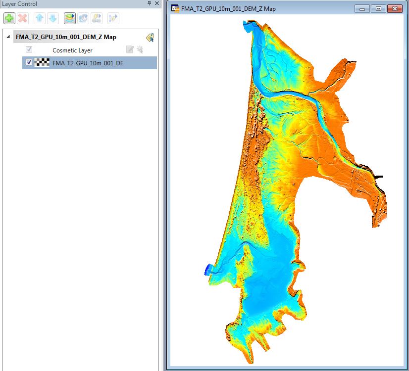
In the image below the DEM_Z check file is shown for the FMA Challenge Model 2 (this model can be downloaded and simulated at a range of cell sizes without a licence). It can be seen that it is easy to visualise the final elevations across the entire model to detect any anomalies.

Back to TUFLOW check files.