Arc Assign DEM Value to Points: Difference between revisions
Jump to navigation
Jump to search
Content deleted Content added
No edit summary |
Chris Huxley (talk | contribs) No edit summary |
||
| Line 9: | Line 9: | ||
<li>Set the input layer as the layer containing the points, the input raster as the DEM and an appropriate output filename.</li> |
<li>Set the input layer as the layer containing the points, the input raster as the DEM and an appropriate output filename.</li> |
||
</ol> |
</ol> |
||
<br> |
|||
{{Tips Navigation |
|||
|uplink=[[ArcGis_Tips | Back to ArcGIS]]}} |
|||
Revision as of 06:13, 31 January 2015
Introduction
This is useful for assign elevation for breakline points from a DEM. This requires spatial analyst.
Method
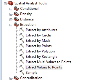
- From the toolboxes select, Spatial Analyst >> Extraction >> Extract Values to Points.
- Set the input layer as the layer containing the points, the input raster as the DEM and an appropriate output filename.

| Up |
|---|