HEC-RAS to TUFLOW: Difference between revisions
Chris Huxley (talk | contribs) |
Chris Huxley (talk | contribs) |
||
| Line 11: | Line 11: | ||
The GIS format type can be either *mif or *shp. Options are also available to automatically trim the processed cross-section GIS and csv data to the main channel region between defined levee markers. |
The GIS format type can be either *mif or *shp. Options are also available to automatically trim the processed cross-section GIS and csv data to the main channel region between defined levee markers. |
||
The HEC-RAS model inputs need to be in SDF format (HEC-RAS export format), and must be geo-referenced using a real world projection. |
The HEC-RAS model inputs need to be in SDF format (HEC-RAS export format), and must be geo-referenced using a real world projection. |
||
== Input Processing (HEC-RAS) == |
== Input Data Processing (HEC-RAS) == |
||
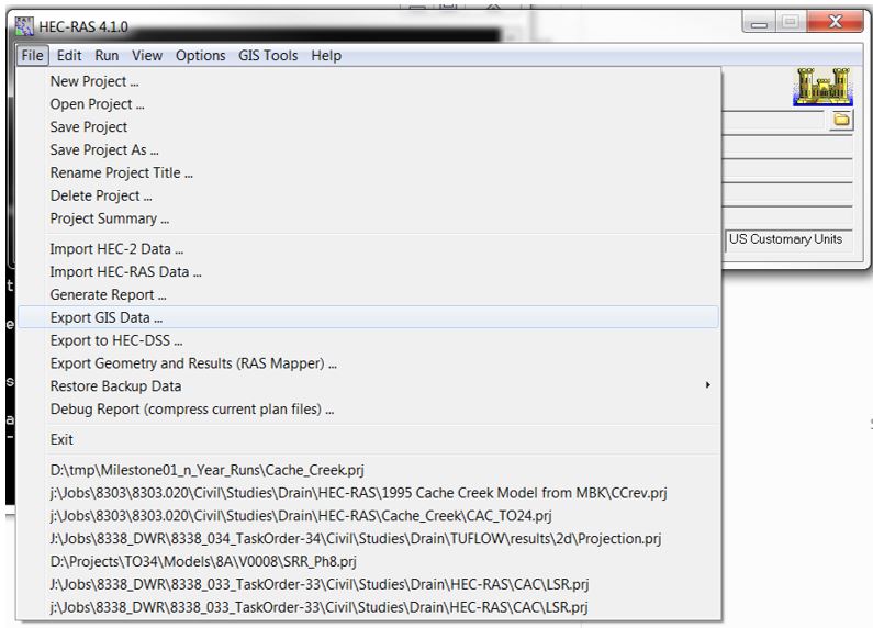
Export the HEC-RAS sdf file using: File >> Export GIS Data... |
Export the HEC-RAS sdf file using: File >> Export GIS Data... |
||
Revision as of 05:21, 5 February 2015
Introduction
This page contains a brief introduction to the methods of converting HEC-RAS model inputs into a format which compatible with TUFLOW. If you have any suggestions to be included in these pages, please email support@tuflow.com.
Model Geometry Conversion
The sdf_to_GIS.exe utility converts HEC-RAS geometric data data into TUFLOW compatible GIS and csv input format. The utility outputs include:
- Centerline location data in GIS format
- Cross-section locations in GIS format
- Cross-section data in csv format
The GIS format type can be either *mif or *shp. Options are also available to automatically trim the processed cross-section GIS and csv data to the main channel region between defined levee markers. The HEC-RAS model inputs need to be in SDF format (HEC-RAS export format), and must be geo-referenced using a real world projection.
Input Data Processing (HEC-RAS)
Export the HEC-RAS sdf file using: File >> Export GIS Data...
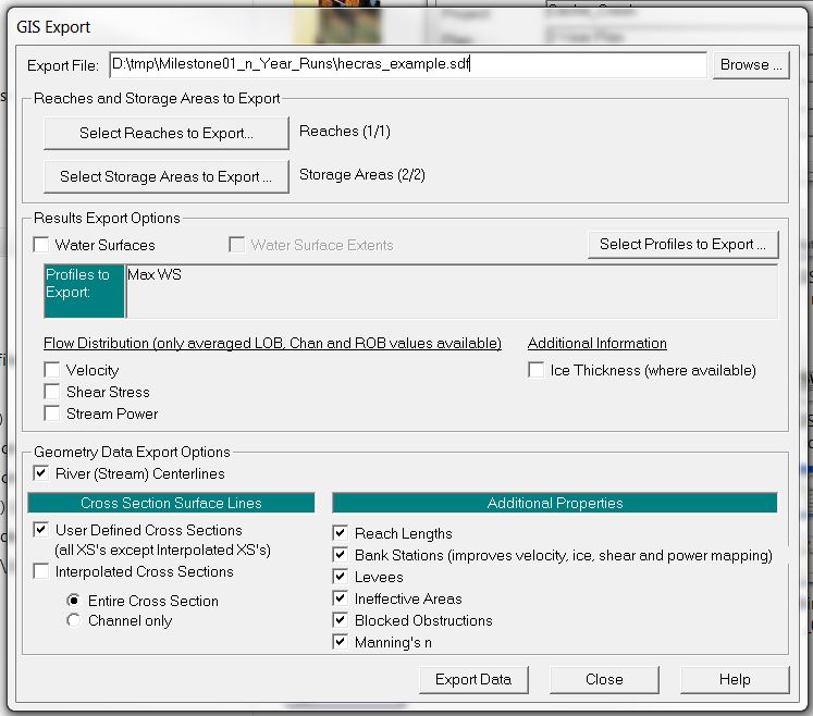
Select the following items within the GIS Export window:
- River (Stream) Centerlines
- User Defined Cross Sections
- Entire Cross Section
- Reach Lengths
- Bank Stations
- Levees
- Ineffective Areas
- Blocked Obstructions
- Manning's n
Utility Description
The utility requires GIS projection information to correctly translate the spatial dataset from SDF format to *mif or *.shp format. This is done by including either a projection or header file in the same folder directory as the SDF file. The utility will use the projection information from this file for the data conversion.
- mif output: Projection.mif or Header.mif
- shp output: Projection.prf or Header.prj
The following error message will be produced if projection information is not available:
ERROR - A Header.prj or Projection.prj file does not exist in folder
Example Syntax (*.mif output)
Description: Convert HEC-RAS sdf data to mif format, trimming cross-section at levee markers (default trim option):
Description: Convert HEC-RAS sdf data to mif format, not trimming cross-section at levee markers:
Example Syntax (*.shp output)
Description: Convert HEC-RAS sdf data to shp format, trimming cross-section at levee markers (default trim option):
Description: Convert HEC-RAS sdf data to shp format, not trimming cross-section at levee markers:
Utility Output (TUFLOW)

