TUFLOW Viewer - Batch Exporting Plots
Tool Description
TUFLOW Viewer offers a tool to batch export plots using a vector layer as the plot location selection object. the tool includes the ability to plot from results that have not been loaded into QGIS yet.
The tool will use the current plot settings at the time of the export request for all outputs. This includes line styles, axis settings, and legend settings. As an alternative to exporting images, the tool can also export csv files, in which case the plot settings won't have any effect on the export. The tool currently only supports the standard time series (from a point layer) or standard cross-sections (from a line layer). It does not support Isodate (date-time) formats.
The Batch Export Tool is initiated using the TUFLOW Viewer drop menu: Export >> Batch Plot and Export Features
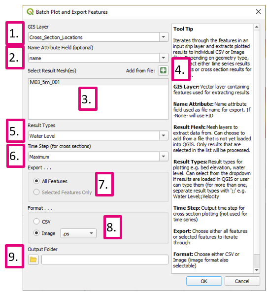
The following image highlights the tool input and output options:
- GIS Layer: Vector layer containing objects defining the location where results are to be extracted from.
- Name Attribute: Name attribute field used as file name for export and chart title. If -None- is selected, the tool uses the feature FID.
- Result Mesh: Mesh layers to extract data from. You can choose to add from a file that is not yet loaded into QGIS. Only results that are selected in the list will be processed.
- Add from a file: Button to browse to results that are not already present in QGIS. If no result layer is currently present in QGIS, Result Types and Timestep options below are not populated. As such, it is recommended that at least one result layer is loaded so that these are populated, making selection of appropriate options in the following fields easier.
- Result Types: Result types for plotting (e.g. bed elevation, water level). Can select from the dropdown if results are loaded in QGIS or user can type them (for more than one, separate result types with ';;' (e.g. Water Level;;Velocity).
- Time Step: Output time step for cross section plotting (not used for time series). Required for cross-sections. If no results are present in QGIS the user will need to input a timestep manually.
- Export: Choose either all features or only currently selected features (in the QGIS map window) to iterate through.
- Format: Choose either CSV or Image.
- Output Folder: Folder location for outputs.
| Up |
|---|
