Check Files 1d xsl
The XSL check file contains information on the input cross-sections where specified as tabular data (as opposed to say a box culvert section which is defined by a height and a width). At each input cross-section a GIS line is output containing the information in the table below.
The .csv 1d_ta_tables check file contains the height varying properties for the section.
The 1d_hydroprop check files which contains information on each of the channels (including interpolated and structures).
Attributes of xsl_check
| Attribute Name | Attribute Description |
|---|---|
| ID | The cross-section ID, this is the input cross-section number and is unique. It is also output in the 1d_ta_tables check file. |
| Manning_n | The Manning's n at the lowest point (bed) in the cross-section. If no roughness value is specified on the cross-section (the Manning's value is specified on the channel), then a value of -1 is output. |
| Elev_at_Bed | The elevation at the lowest point in the cross-section. |
| Elev_at_Top | The elevation at the highest point in the cross-section. |
| Depth | The depth at the top of section. i.e. the elevation at the top - the elevation at the bed. |
| Top_Flow_Width | The effective flow width at the top of the cross section. See the _ta_tables check file for the effective flow width at each elevation. Note, the effective width is calculated based on the Manning’s n value, if the Manning’s n values differ throughout the channel, the width is proportionally adjusted so the whole cross-section uses a single Manning’s n. |
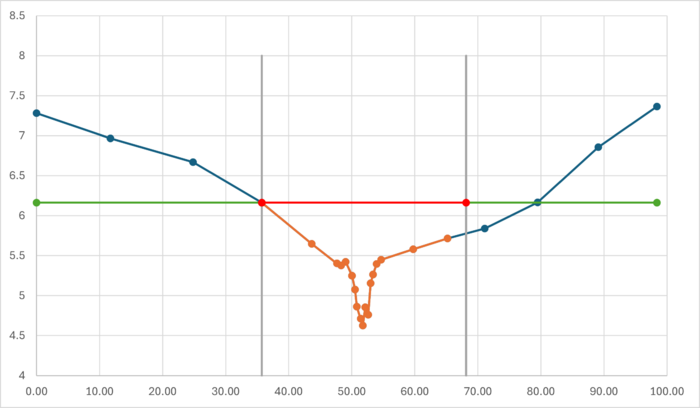
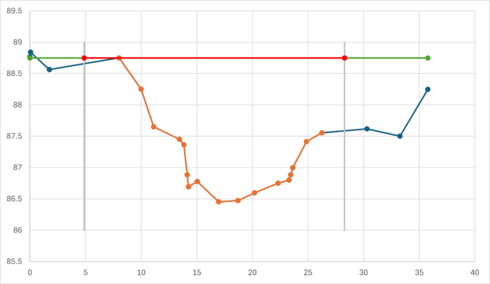
| Top_Storage_Width | The storage width at the top of the cross-section. See note below for how this is calculated when using negative Manning's n or M values to deactivate parts of cross-sections. |
| Top_Flow_Area | The flow area at the top of the cross-section. |
| Top_Wet_Perimeter | The wetted perimeter at the top of the cross-section. |
| Source_File | The source file (.csv) file which the data was read from. |
| Attributes | The remaining attributes (the source file is excluded, see the above) in the GIS layer. |
| Source_Layer | The GIS file that the cross-section was specified in. |
Top_Storage_Width calculation when portion of cross-section is deactivated
Every cross section is being divided into vertical parallel channels, where the bounds are midway in between the XZ points. Where outer parts of the channel are being made inactive (e.g. with Manning’s n -1, for more information see here) TUFLOW will place vertical walls at the midway point between the XZ points where the cross-section is inactive. The height limit is the highest active XZ point.
The below example shows the calculated top storage width in red. In blue is the full cross section, orange is the active part of the channel, green is highest elevation of the not ignored part of the channel and grey are the vertical bounds.
This can become more complicated if the highest point in the active part of the channel has a lower adjacent inactive point. In this case, the width calculation considers half of the distance between these two XZ points as well, as shown below.
| Up |
|---|

