Difference between revisions of "MI Creating Google Earth KMZ"
Jump to navigation
Jump to search
Chris Huxley (talk | contribs) |
Chris Huxley (talk | contribs) |
||
| Line 1: | Line 1: | ||
<ol> | <ol> | ||
<li> Load the Google Earth Connection Utility using Tools >> Tool Manager... <br> | <li> Load the Google Earth Connection Utility using Tools >> Tool Manager... <br> | ||
| − | [[File:MapInfo_to_Google_Earth_000.JPG|300px]] | + | [[File:MapInfo_to_Google_Earth_000.JPG|300px]][[File:MapInfo_to_Google_Earth_001.JPG|400px]]<br> |
| − | [[File:MapInfo_to_Google_Earth_001.JPG|400px]]<br> | ||
<li> Open the MapInfo table containing the data you wish to export to Google Earth. <br> | <li> Open the MapInfo table containing the data you wish to export to Google Earth. <br> | ||
<li> Select the object or objects you wish to export to Google Earth. <br> | <li> Select the object or objects you wish to export to Google Earth. <br> | ||
Latest revision as of 00:15, 29 June 2016
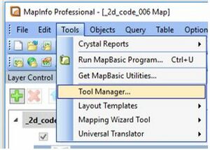
- Load the Google Earth Connection Utility using Tools >> Tool Manager...

- Open the MapInfo table containing the data you wish to export to Google Earth.
- Select the object or objects you wish to export to Google Earth.
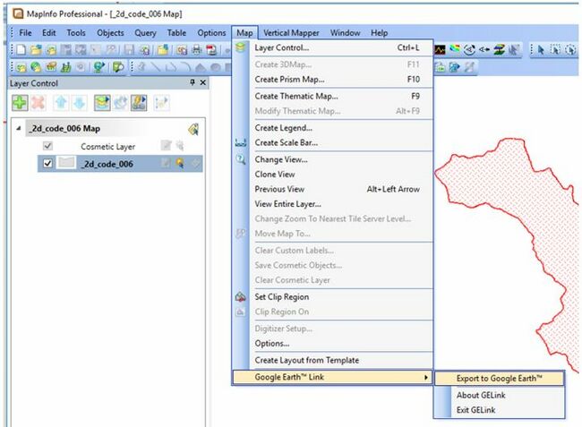
- Select "Export to Google Earth" via the Map Options.
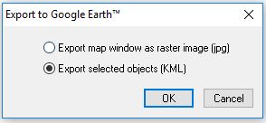
- Select "Export selected objects (KML)"
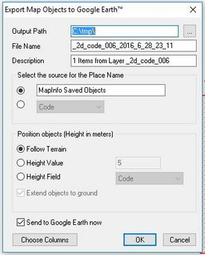
- Set the export options to the folder location and filename you desire.