Difference between revisions of "TUFLOW Viewer - Load Results - Time Series FM"
Jump to navigation
Jump to search
Ellis Symons (talk | contribs) (Created page with "===Tool=== ===Examples=== ===Links=== * Load Results * Load Results - Map Outputs * TUFLO...") |
Ellis Symons (talk | contribs) |
||
| Line 1: | Line 1: | ||
===Tool=== | ===Tool=== | ||
| + | Load Flood Modeller time series results. The import process will require an exported georeferenced .gxy file and result csv file from Flood Modeller. Users also have the option of specifying a dat file containing river section data which will load cross sections and bed elevation data.<br> | ||
| + | [[File: LoadResults_TimeSeriesFM_img.PNG]]<br> | ||
| + | <ol> | ||
| + | <li> '''GXY File''' - Georeferenced file containing unit (node) data and link data. Must be exported from Flood Modeller. | ||
| + | <li> '''Section Data''' - Flood Modeller DAT file containing information on river sections, conduits, structures etc. This is an optional input and not required to view results. If included, users will be able to view river cross section data (with/without water level results) and bed elevation data when plotting long sections. | ||
| + | <li> '''Result CSV Files''' - Results exported from Flood Modeller as in the format "Column per node" (file must be exported in this format). It is recommended that header information is included when you export the results, however not a requirement. Multiple CSV files can be selected - this could be separate result types from the same results (water level, velocity etc.) or results from different events. TUFLOW Viewer will try and group result types from the same event (which is why including header information is recommended). Alternatively it is ok to import results that have multiple result types in the one file. Currently only Stage (water level), velocity, and flow will be imported. | ||
| + | </ol> | ||
===Examples=== | ===Examples=== | ||
===Links=== | ===Links=== | ||
Revision as of 04:29, 23 February 2021
Tool
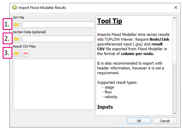
Load Flood Modeller time series results. The import process will require an exported georeferenced .gxy file and result csv file from Flood Modeller. Users also have the option of specifying a dat file containing river section data which will load cross sections and bed elevation data.
- GXY File - Georeferenced file containing unit (node) data and link data. Must be exported from Flood Modeller.
- Section Data - Flood Modeller DAT file containing information on river sections, conduits, structures etc. This is an optional input and not required to view results. If included, users will be able to view river cross section data (with/without water level results) and bed elevation data when plotting long sections.
- Result CSV Files - Results exported from Flood Modeller as in the format "Column per node" (file must be exported in this format). It is recommended that header information is included when you export the results, however not a requirement. Multiple CSV files can be selected - this could be separate result types from the same results (water level, velocity etc.) or results from different events. TUFLOW Viewer will try and group result types from the same event (which is why including header information is recommended). Alternatively it is ok to import results that have multiple result types in the one file. Currently only Stage (water level), velocity, and flow will be imported.
