Difference between revisions of "TUPLOT External"
Ellis Symons (talk | contribs) |
Ellis Symons (talk | contribs) (→About) |
||
| Line 1: | Line 1: | ||
=About= | =About= | ||
| − | TUPLOT external is a 1D and 2D time series result viewer. It looks to provide the functionality of TUPLOT | + | TUPLOT external is a 1D and 2D time series result viewer. It looks to provide the functionality of the QGIS TUPLOT plugin in an external program that can be called from other GIS platforms (e.g. ArcGIS). |
=How to Use= | =How to Use= | ||
Revision as of 10:31, 2 March 2018
About
TUPLOT external is a 1D and 2D time series result viewer. It looks to provide the functionality of the QGIS TUPLOT plugin in an external program that can be called from other GIS platforms (e.g. ArcGIS).
How to Use
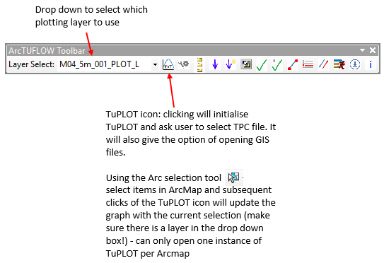
The toolbar and button functions are displayed below.
- The TuPLOT viewer can be initiated by clicking the TuPLOT icon
- This will prompt the user to select a TUFLOW Plot Control File (*.tpc)
- The next prompt will allow the user to automatically import the relevant GIS files associated with the *.tpc
- Use the dropdown box to select a PLOT layer (Points, Lines, Regions)
- Select layers you would like to view results for and click the TuPLOT icon again
- Each selection update requires the user to click the TuPLOT icon to update the graph
Planned Future Enhancements
Planned future enhancements include:
- ArcTUFLOW toolbox tools added to Toolbar
- Full functionality from the TUFLOW QGIS plugin
- Secondary axis
- ARR2016 functionality (pulling statistics from results)
- Opening multiple *.tpc files at once
- Exporting data from display
- Enhance viewer association with ArcGIS
- Exit with ArcGIS
- Minimise with ArcGIS
- Window always in front of ArcGIS but not always topmost
If you have any suggestions on additional functionality or improvement, or find a bug, please email a description to support@tuflow.com
How it works
Using 'dockable windows' internally in ArcGIS to graph results requires the setup of a graph template for each graphed scenario (for example: a template for 1 result on the primary axis, a template for 2 results on primary axis, a template for 1 result on the primary axis and 1 result on the secondary axis... a template for n results on primary axis and n results on secondary axis). This would be time consuming to set up, and potentially impossible to capture all scenarios. The stand alone TuPLOT viewer uses a program external to ArcGIS for graphing and viewing 1D results and 2D time series results as a solution to this problem.
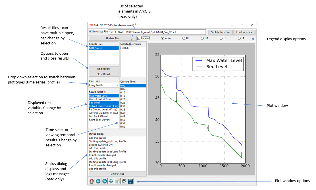
The stand alone TuPLOT viewer uses Python (the package installed with ArcGIS) as a base for the viewer. ArcGIS and the TuPLOT viewer communicate using an interface file (*.int) that is written by ArcMap and read by TuPLOT. The *.int file is written automatically when TuPLOT is initiated and deleted when TuPLOT is closed. If TuPLOT crashes, the *.int file may not be deleted. If this occurs many times, a build up of *.int files may occur in the same folder as the *.tpc. The user should feel free to delete these manually if this occurs without fear of interfering the the TuPLOT viewer. The user may also manually select a desired *.int file using the Set Interface File button in the TuPLOT window, though generally this should not be required.
The stand alone TuPLOT viewer is also planned to be made available in both QGIS and Mapinfo.

