Check Files 2d zsh zpt
The _2d_zsh_zpt or _2d_zsh_zpt_P is only created if a "Read GIS Z Shape ==" command has been specified in the model. This file contains information on all the elevations points (zpts) that have been altered by the Read GIS Z Shape commands.
Attributes of _zsh_zpt check file
| Attribute Name | Attribute Description |
|---|---|
| dZ | The amount by which the elevation has been changed by the Z Shape. A positive value indicates that the elevation has been increased by the GIS layer and a negative value indicates that the elevation has been lowered. For example a value of 0.3 would indicate that elevation point has been raised by 0.3 (metres or feet if running in US Customary units.) |
| Elevation (ZExact if SGS is used) | The elevation within the cell. If SGS is used, the elevation at the exact location of the cell centre, face mid-point, or cell corner. |
| dZMin (only if SGS is used) | The change in minimum elevation inside cells, along faces or at corners. |
| ZMin (only if SGS is used) | Minimum elevation within the cell. |
| Source | The path to the GIS layer which has caused the elevation point to be modified. |
Note: More than one Z Shape layer can modify the same elevation point. For example, if two separate breaklines layers are applied which intersect, then the later occurrence in the TUFLOW Geometry control file (.tgc) is given preference. Multiple objects within a single GIS layer may also modify the same elevation point (zpt), for example overlapping polygons. In the _zsh_zpt check file, a separate reporting point is created for each modification to a zpt's elevation from all objects, in all Z Shape layers. If there are multiple modifications to an elevation point, the dz value is the most recent change from the last assigned elevation. For example, if an elevation point starts with an elevation of 10.0, which is raised to 12.0 (dz = 2.0), before being raised to 12.5 by a second Z Shape layer, the dz reported for the second layer will be 0.5 and not 2.5 (i.e. compared to the base elevation). Where a zpt has been modified multiple times, the _zsh_zpt check file will include multiple objects at the same zpt location that details each change from the previous elevation. The final elevations are reported in the 2d_zpt check file.
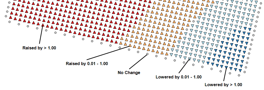
In QGIS, with default TUFLOW styles symbology applied, this layer has five styles:
- A red triangle pointing up indicates that the zpt has been raised my more than 1.00
- A orange triangle pointing up indicates that the zpt has been raised my 0.01 - 1.00
- A grey circle indicates that no change has occurred (for example, a Z Shape with the shape option "Max", which is below the existing elevation)
- A light blue triangle pointing down indicates that the zpt has been lowered by 0.01 - 1.00
- A blue triangle pointing down indicates that the zpt has been lowered by more than 1.00
These can be seen in the image below:

| Up |
|---|