Method
Copy the contents of the Module_Data\Module_06\2D_Road_Crest folder into the TUFLOW\model\gis folder. This contains the 2d_zsh_M06_Rd_Crest_001 layer used to amend the road crest elevation.
Open the newly saved layer 2d_zsh_M06_Rd_Crest_001 in Mapinfo. This layer contains a single polyline which we will use to overwrite the road crest elevations previously defined in Module 3. Populate the line with the following:
| Attribute
|
Value
|
| Z |
42.75
|
| dz |
0
|
| Shape_Width_or_dMax |
15
|
| Shape_Options |
MAX
|
| X |
0
|
| Y |
0
|
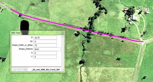
The values entered will define a road crest with a constant 42.75m elevation with a width of 15m. The MAX option ensures that zpt elevations are only altered if the current zpt elevations (defined by any prior commands within the tgc file) are lower than 42.75m.
Toggle Editing to make the changes, then save your table. Re-export the layer as MID/MIF files. The 2D zsh defining the road crest is now ready for TUFLOW.
A 2D zsh layer has been used to define the road crest elevation. Please return to the main page of module 6.
