Tute SMS M01 Create Projection Archive
Jump to navigation
Jump to search
A "Projection" refers to a map projection (for example UTM). In SMS software, a projection can be associated with a project, and data can be reprojected from one projection to another. The SMS software utilizes the Global Mapper (TM) library which supports hundreds of standard projections.
Note: Previous SMS software versions referred to projections as "coordinate systems" and reprojection as "coordinate conversion".
To set the GIS projection:
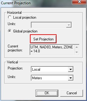
- Select the current projection, or the projection currently associated with the project, by selecting the Display >> Projection menu command.
- Select Global Projection and click on the Set Projection button to select a map projection for the project.

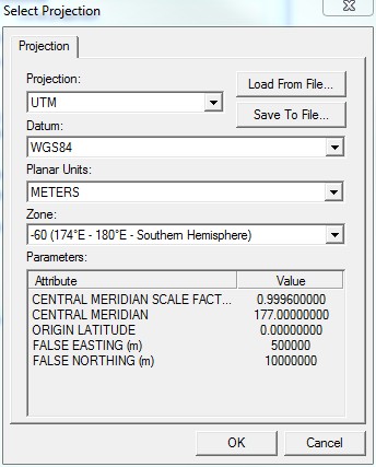
The Select Projection window gives options to select the current projection (including the datum, planar units, and zone) save the specified projection, or load a previously saved projection. Attributes of the currently selected projection are given in a table at the bottom of this window.
- Select "UTM" for Projection, "WGS84" for Datum, "METERS" for the Planar Units, and "-60" (174°E - 180°E - Southern Hemisphere) for Zone. Leave Vertical Projection to "Local" but make sure that the Units are set to "Meters". Click OK twice to save the selected projection settings.

When run from within SMS, TUFLOW will use the current SMS projection to define the projection of the TUFLOW model. There is no need to create a projection.mif / projection.prj file, or to add any projection commands to the M01_5m_001.tcf file. There is also no need to run TUFLOW to create empty template GIS layers.
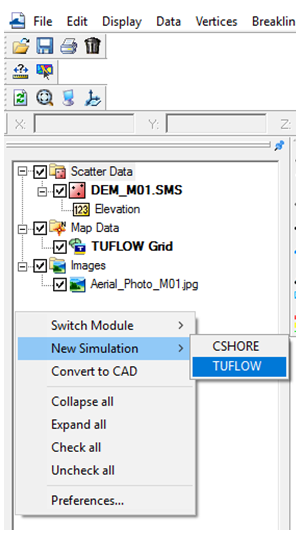
- Next we will initialise the TUFLOW simulation catalogue. Right click the right click on the blank space in the Project Explorer below the Scatter Data, Map Data and Images tabs. Select New Simulation >> TUFLOW.
- Rename the simulation Sim with M01_5m_002. This will be the name of our TUFLOW model.
- After setting the projection and initialising the TUFLOW simulation catalogue please progress to Define Location and Dimensions of the 2D Domain.
