Difference between revisions of "QGIS SWMM Convert XPSWMM GIS Inlet Layers to SWMM"
(→Usage) |
|||
| Line 23: | Line 23: | ||
=== Parameters === | === Parameters === | ||
<ol> | <ol> | ||
| − | <li>''' | + | <li>'''GIS layer with inlet information:''' |
| − | <li>''' | + | <li>'''Inlet name field:''' |
| − | <li>''' | + | <li>'''Inlet elevation field:''' |
| − | <li>''' | + | <li>'''Inlet 2d capture flag (1=has 2d connection) field:''' |
| − | <li>''' | + | <li>'''Inlet discharge equation coefficient field:''' |
| − | <li>''' | + | <li>'''Inlet discharge exponent field:''' |
| − | <li>''' | + | <li>'''Inlet connection width:''' |
| − | <li>''' | + | <li>'''CRS:''' The CRS (Coordinate Reference System) for the TUFLOW-SWMM project. |
| − | <li>''' | + | <li>'''SWMM inp file (for inlet definition and curves):''' Determines the location and filename of the output SWMM inp file. |
| − | + | <li>'''GeoPackage file for inlet usage (for inlet placement):''' Determines the location and filename of the output GeoPackage. | |
| − | |||
| − | |||
| − | <li>''' | ||
</ol> | </ol> | ||
<br> | <br> | ||
Revision as of 15:19, 14 December 2023
Introduction
This tool converts an XPSWMM GIS layer with 2D connectivity information for use with TUFLOW-SWMM. The tool works on discharges computed from the equation: Q=coefficient*depthexponent. This processing tool generates a GIS layer that can be used to with the "Read GIS SWMM Inlet Usage" command to link SWMM inlets to a TUFLOW 2D model.
To export the GIS layer required from XPSWMM or the XPSWMM Viewer:
- Right click on the nodes layer and choose "Export to GIS."
- Expand the tree folders "Hydraulics Node\HDR Node Data"
- Select Node 2D Inflow Capture Flag, Gound Elevation(Spill Crest), 2D Inflow Capture Coefficient, and 2D Inflow Capture Exponent
- Remove the paranthesis from "Ground Elevation(Spill Crest)." Required for some versions of QGIS
- Set the GIS filename
- Click Export
The inlets require a name for each combination of coefficient and exponent that must be added to the GIS layer.
Once the layer is setup, run the tool and select the parameters for the appropriate fields. The ground elevation should be used for the "Inlet elevation field." The CRS should match the TUFLOW-SWMM project.
Usage
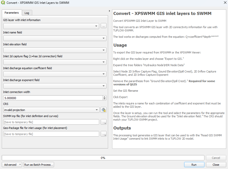
This tool, Convert - XPSWMM GIS inlet layers to SWMM, can be found in the QGIS processing toolbox panel under 'TUFLOW > SWMM'. To open the Processing Toolbox Panel, navigate to 'Processing' in the menubar and select 'Toolbox'.

Parameters
- GIS layer with inlet information:
- Inlet name field:
- Inlet elevation field:
- Inlet 2d capture flag (1=has 2d connection) field:
- Inlet discharge equation coefficient field:
- Inlet discharge exponent field:
- Inlet connection width:
- CRS: The CRS (Coordinate Reference System) for the TUFLOW-SWMM project.
- SWMM inp file (for inlet definition and curves): Determines the location and filename of the output SWMM inp file.
- GeoPackage file for inlet usage (for inlet placement): Determines the location and filename of the output GeoPackage.
Example
| Up |
|---|
