Difference between revisions of "TUFLOW CATCH Tutorial M01 Draft"
| Line 6: | Line 6: | ||
= Project Initialisation = | = Project Initialisation = | ||
| − | TUFLOW CATCH models are separated into a series of folders which contain the input and output files. The recommended set up for the model directory and sub-folders is shown below. For a more detailed description, refer to the <u>[https://docs.tuflow.com/catch/latest/ TUFLOW CATCH Manual]</u>. | + | TUFLOW CATCH models are separated into a series of folders which contain the input and output files. The recommended set up for the model directory and sub-folders is shown below. The top level folder should be called '''Modelling''' and contain three subfolders: '''TUFLOW'''', '''TUFLOWCatch''' and '''TUFLOWFV'''. <font color="red"> more info?? </font> For a more detailed description, refer to the <u>[https://docs.tuflow.com/catch/latest/ TUFLOW CATCH Manual]</u>.<br> |
| − | + | <ol> | |
| + | [[File:Tute M01 Directory Structure v3.png|left]] | ||
| + | {| class="wikitable" | ||
| + | ! style="background-color:#005581; font-weight:bold; color:white;"| Folder | ||
| + | ! style="background-color:#005581; font-weight:bold; color:white;" width=10%| Sub-Folder | ||
| + | ! style="background-color:#005581; font-weight:bold; color:white;" width=80%| Description | ||
| + | |- | ||
| + | |rowspan="8" style="text-align: center;"|TUFLOW | ||
| + | | bc_dbase|| Boundary condition database(s) and input time-series data. | ||
| + | |- | ||
| + | | check || GIS and other check files to carry out quality control checks (use Write Check Files). | ||
| + | |- | ||
| + | | model ||Geometry (TGC), Boundary (TBC) and other model control text files (i.e. no GIS files). | ||
| + | |- | ||
| + | | model\gis || GIS layers that are inputs to the 2D and 1D model domains are contained within this folder, model\gis is typically used for all QGIS and ArcGIS files. | ||
| + | |- | ||
| + | | model\mi || GIS layers that are inputs to the 2D and 1D model domains are contained within this folder, model\mi is typically used for MapInfo formatted GIS files. | ||
| + | |- | ||
| + | | results|| TUFLOW outputs the results to this folder in specified formats. | ||
| + | |- | ||
| + | | runs|| TUFLOW Control Files (TCF). | ||
| + | |- | ||
| + | | runs\log || TUFLOW log files (TLF) and messages layers. | ||
| + | |} | ||
| + | </ol> | ||
= GIS Inputs = | = GIS Inputs = | ||
Revision as of 12:03, 19 March 2025
Page Under Construction
Introduction
In this module, a TUFLOW CATCH pollutant export model is developed.
TUFLOW CATCH Tutorial Module 1 build from the model created in TUFLOW Tutorial Module 6 - Part 3. The completed TUFLOW Module 6 (part 3) is provided in the TUFLOW_CATCH_Module_01\Modelling folder of the download dataset as the starting point for this tutorial. If you are not already familiar with TUFLOW, we recommend first completing Module 1, 2, 3 and 6 of the TUFLOW Tutorials to establish an understanding of 1D and 2D TUFLOW modelling, as well as direct rainfall models.
Project Initialisation
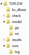
TUFLOW CATCH models are separated into a series of folders which contain the input and output files. The recommended set up for the model directory and sub-folders is shown below. The top level folder should be called Modelling and contain three subfolders: TUFLOW', TUFLOWCatch and TUFLOWFV. more info?? For a more detailed description, refer to the TUFLOW CATCH Manual.
| Folder | Sub-Folder | Description |
|---|---|---|
| TUFLOW | bc_dbase | Boundary condition database(s) and input time-series data. |
| check | GIS and other check files to carry out quality control checks (use Write Check Files). | |
| model | Geometry (TGC), Boundary (TBC) and other model control text files (i.e. no GIS files). | |
| model\gis | GIS layers that are inputs to the 2D and 1D model domains are contained within this folder, model\gis is typically used for all QGIS and ArcGIS files. | |
| model\mi | GIS layers that are inputs to the 2D and 1D model domains are contained within this folder, model\mi is typically used for MapInfo formatted GIS files. | |
| results | TUFLOW outputs the results to this folder in specified formats. | |
| runs | TUFLOW Control Files (TCF). | |
| runs\log | TUFLOW log files (TLF) and messages layers. |
GIS Inputs
TUFLOW Boundary Condition Database (bc_dbase)
Materials
TUFLOW Soil File (.tsoilf)
Simulation Control Files
TGC
TBC
ECF
TCC
Running the Simulation
Troubleshooting?
