Check Files 1d inverts: Difference between revisions
Jump to navigation
Jump to search
Content deleted Content added
Created page with "To be created" |
No edit summary |
||
| (3 intermediate revisions by 2 users not shown) | |||
| Line 1: | Line 1: | ||
The GIS layer contains information of the 1D node and 1D channel inverts. The channel invert does not necessarily have to equal the node invert. For example a 1D channel entering or leaving a storage basin, may be well above the basin invert.<br> |
|||
To be created |
|||
<br> |
|||
'''Attributes of inverts_check'''<br> |
|||
{| align="center" class="wikitable" width="75%" |
|||
! style="background-color:#005581; font-weight:bold; color:white;"| Attribute Name |
|||
! style="background-color:#005581; font-weight:bold; color:white;" width=75%| Attribute Description |
|||
|- |
|||
| ID||The ID of the node or channel. |
|||
|- |
|||
| Location||'''"Node"''' denotes the invert at the 1D node.<br> |
|||
'''"U/S"''' and '''"D/S"''' deontes the invert at the upstream and downstream ends of the channel respectively. |
|||
|- |
|||
| Invert||The invert in metres or feet. |
|||
|} |
|||
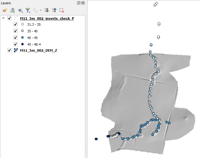
In the image below the 1d_inverts_check is shown for the <u>[[FMA_Challenge_1_(1D-2D_linked) | FMA challenge model 1]]</u>, the layer is styled by the invert elevation.<br> |
|||
<br> |
|||
[[File:1d_inverts_check_01a.png]] |
|||
<br><br> |
|||
{{Tips Navigation |
|||
|uplink=[[TUFLOW_Check_Files | TUFLOW Check Files]] |
|||
}} |
|||
Latest revision as of 12:25, 5 January 2026
The GIS layer contains information of the 1D node and 1D channel inverts. The channel invert does not necessarily have to equal the node invert. For example a 1D channel entering or leaving a storage basin, may be well above the basin invert.
Attributes of inverts_check
| Attribute Name | Attribute Description |
|---|---|
| ID | The ID of the node or channel. |
| Location | "Node" denotes the invert at the 1D node. "U/S" and "D/S" deontes the invert at the upstream and downstream ends of the channel respectively. |
| Invert | The invert in metres or feet. |
In the image below the 1d_inverts_check is shown for the FMA challenge model 1, the layer is styled by the invert elevation.

| Up |
|---|