FM Tute M01 QGIS x1D Nodes: Difference between revisions
Jump to navigation
Jump to search
Content deleted Content added
Andrew.Sims (talk | contribs) No edit summary |
Andrew.Sims (talk | contribs) No edit summary |
||
| Line 10: | Line 10: | ||
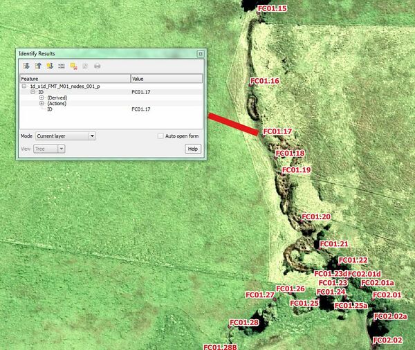
<li> Interrogate one of the digitised points and inspect the attributes. Note that each point has a unique name which correlates to a RIVER, INTERPOLATE or REPLICATE unit within the Flood Modeller model. At junctions, both the upstream and downstream nodes must be digitised within this layer.</li> |
<li> Interrogate one of the digitised points and inspect the attributes. Note that each point has a unique name which correlates to a RIVER, INTERPOLATE or REPLICATE unit within the Flood Modeller model. At junctions, both the upstream and downstream nodes must be digitised within this layer.</li> |
||
<li> Save the file in preparation for reading into TUFLOW. |
<li> Save the file in preparation for reading into TUFLOW. |
||
[[File:FMT_QGISx1D_Nodes.JPG|600px]] |
|||
{| align="center" class="wikitable" |
{| align="center" class="wikitable" |
||
Revision as of 18:09, 24 October 2016
- Open the FloodModeller_Nodes. GIS layer from Module_Data\Module_01\gis folder.
- Save as 1d_x1d_FMT_M01_nodes_001.shp within the TUFLOW\model\gis folder.
- Open the GIS layer 1d_x1d_FMT_M01_nodes_001.shp_p within QGIS.
- Interrogate one of the digitised points and inspect the attributes. Note that each point has a unique name which correlates to a RIVER, INTERPOLATE or REPLICATE unit within the Flood Modeller model. At junctions, both the upstream and downstream nodes must be digitised within this layer.
- Save the file in preparation for reading into TUFLOW.
The node IDs are case-sensitive as this is a requirement of Flood Modeller Please return to the Flood Modeller Tutorial Model module 1 page here.
Introduction
This page describes the method of creating TUFLOW GIS based layers to reference the nodes within the Flood Modeller model
