SCALGO Live Tips: Difference between revisions
Tuflowduncan (talk | contribs) |
Tuflowduncan (talk | contribs) |
||
| Line 22: | Line 22: | ||
[[File:Download Selection3.png|200px]] |
[[File:Download Selection3.png|200px]] |
||
Choose the desired resolution, output format and projection. For elevation data, the data can be downloaded as a ''Geotiff'', ''ENVI .hdr labelled raster'', ''ERDAS Imagine (img)'', ''Arc/Info (aka ESRI) ASCII Grid (.asc)'' and ''ASCII Gridded XYX''. Currently TUFLOW only supports the ''Arc/Info (aka ESRI) ASCII Grid (.asc)'' format. The 2023 version of TUFLOW will support Geotiffs although the downloaded Geotiff will need to be converted to one supported by TUFLOW. This can be done using an approach outlined [[Raster_Format_Conversion_Using_gdal_translate| here]].<Br> |
Choose the desired resolution, output format and projection. For elevation data, the data can be downloaded as a ''Geotiff'', ''ENVI .hdr labelled raster'', ''ERDAS Imagine (img)'', ''Arc/Info (aka ESRI) ASCII Grid (.asc)'' and ''ASCII Gridded XYX''. Currently TUFLOW only supports the ''Arc/Info (aka ESRI) ASCII Grid (.asc)'' format. The 2023 version of TUFLOW will support Geotiffs although the SCALGO Live downloaded Geotiff format will need to be converted to one supported by TUFLOW. This can be done using an approach outlined [[Raster_Format_Conversion_Using_gdal_translate| here]]. Future versions of TUFLOW will support further Geotiff formats allowing direct support of those Geotiffs downloaded from SCALGO Live. <Br> |
||
For vector data, this can be downloaded as a ''Geopackage (gpkg)'', ''Shapefile (shp)'', ''GeoJSON (geojson)'', ''MapInfo Tab (tab)'' and ''DXF (dxf)'' format. Currently TUFLOW supports shapefiles but will support Geopackages in the 2023 release of TUFLOW. MapInfo Tab files can be converted to MIF/MID files for use with TUFLOW.<Br> |
For vector data, this can be downloaded as a ''Geopackage (gpkg)'', ''Shapefile (shp)'', ''GeoJSON (geojson)'', ''MapInfo Tab (tab)'' and ''DXF (dxf)'' format. Currently TUFLOW supports shapefiles but will support Geopackages in the 2023 release of TUFLOW. MapInfo Tab files can be converted to MIF/MID files for use with TUFLOW.<Br> |
||
Revision as of 00:33, 11 January 2023
Introduction
SCALGO Live is a cloud-based terrain analysis tool which provides an interactive assessment of topographic changes on the potential flood risk. Topography, and user-defined modifications, can be exported in a range of formats which can then be utilised within TUFLOW as the DTM dataset.
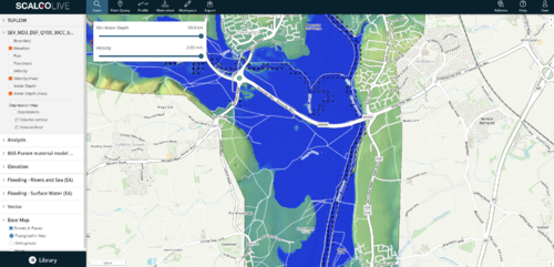
SCALGO Live also supports importing, visualizing, and sharing results from hydrodynamic model simulations, including time-series data, through hydrodynamic modelspaces. This allows the user to visualise TUFLOW results in SCALGO Live. Both of these options are described in the below sections.
Exporting Terrain Data from SCALGO Live for use in TUFLOW
SCALGO Live contains extensive elevation datasets which although openly available from other sources, can be easily exported from SCALGO Live for use within TUFLOW. As well as elevation datasets, there are also landcover, soils and mapping datasets which can be obtained. The datasets are country specific so may vary depending on your SCALGO Live subscription.
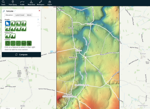
- In order to do this, first the user must make a Workspace of their chosen study area within SCALGO LIVE.
- Once created, it is possible to use the existing elevation datasets or to make additional edits. See the SCALGO Live Manual Editing Page for more information.
- With any edits having been made, choose the Export Menu on the toolbar at the top of the workspace and choose to 'Download Data. Data can be downloaded for the whole workspace area of a selection. Take care as there is a configurable limit to the area of data that can be downloaded.
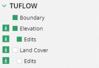
- In the Library panel, select the download icon next to the dataset to be downloaded.
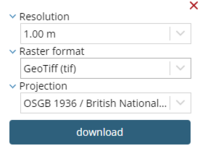
Choose the desired resolution, output format and projection. For elevation data, the data can be downloaded as a Geotiff, ENVI .hdr labelled raster, ERDAS Imagine (img), Arc/Info (aka ESRI) ASCII Grid (.asc) and ASCII Gridded XYX. Currently TUFLOW only supports the Arc/Info (aka ESRI) ASCII Grid (.asc) format. The 2023 version of TUFLOW will support Geotiffs although the SCALGO Live downloaded Geotiff format will need to be converted to one supported by TUFLOW. This can be done using an approach outlined here. Future versions of TUFLOW will support further Geotiff formats allowing direct support of those Geotiffs downloaded from SCALGO Live.
For vector data, this can be downloaded as a Geopackage (gpkg), Shapefile (shp), GeoJSON (geojson), MapInfo Tab (tab) and DXF (dxf) format. Currently TUFLOW supports shapefiles but will support Geopackages in the 2023 release of TUFLOW. MapInfo Tab files can be converted to MIF/MID files for use with TUFLOW.
Once downloaded, the datasets can then be used within a TUFLOW model, either to provide elevation data, land cover data or locations of where topographic edits are to be made within the TUFLOW model (these will need further attributes added to them).
Importing TUFLOW Results in SCALGO Live
SCALGO Live also supports importing, visualizing, and sharing results from hydrodynamic model simulations, including time-series data, through hydrodynamic modelspaces.
- With SCALGO LIVE open, within the Library, select ModelSpaces and Choose to Create new modelspace.
- In the resulting dialogue select the TUFLOW results. You’ll need to select the XMDF file, the xmdf.sup file as well as the .2dm file for the set of simulation results of interest.
- At this stage, the results will be uploaded to SCALGO Live. This can take some time depending on the result sizes.
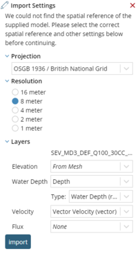
- Provide the Import settings. Primarily this is the projection. Everything else should be pre-populated with the appropriate value. Click Import.
- The import can then take a few moments with a progress bar reporting progress. Once the import is complete, it’s possible to select the relevant dataset and display within the SCALGO Live interface.
A summary of the tools within SCALGO Live for analysing modelspaces can be found at the following page
