Search results
Jump to navigation
Jump to search
File:Tute M01 Saga Zpt NullRemoved.png Saga: Module 1 with Null Zpts Removed(960 × 895 (118 KB)) - 14:29, 25 August 2011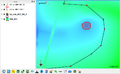
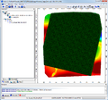
File:Tute M01 QGIS 2d sa1.png Tute M01: QGIS, 2d_sa step 1.(891 × 550 (130 KB)) - 17:00, 28 December 2011
File:M04 1d2d 01.png Tute M04: 1D/2D section 1(564 × 724 (56 KB)) - 16:38, 2 July 2012- Particularly, check if the inputs for column 1 and column 2 in the bc_dbase file are complete as appropriate from the t [[File:Error 0142(1).jpg|300px]]999 bytes (161 words) - 23:59, 11 December 2023
- |tuflow_message=ERROR 1343 - In ',A4,1X,a,' table above, Column 1 values not increasing. Values: ',a,' then |message_desc=The value in column 1 of the 1d_ta file does not increase as it progresses, as shown in the examp696 bytes (125 words) - 10:34, 23 December 2022
- ...de </tt></font><font color="red"><tt>= </tt></font><font color="black"><tt>1</tt></font>.674 bytes (103 words) - 11:59, 23 December 2022
File:Tute M01 QGIS projection1.png Tute M01: QGIS - set projection step 1(459 × 523 (21 KB)) - 09:58, 21 December 2011
File:Tute M01 Saga Zpts All.png Saga: Module 1, all Zpts and DEM(950 × 848 (99 KB)) - 11:48, 25 August 2011
File:12da TIN export screenshot.JPG #1) 12d screen shot for Error 2416(622 × 514 (97 KB)) - 00:58, 11 July 2015
File:Excel Default Chart01.png Setting Default Chart Type in Excel 1(729 × 358 (66 KB)) - 10:24, 28 June 2012
File:M04 MI hotlinking01.png Tute M04: Enabling Hotlinking in MapInfo 1(403 × 168 (16 KB)) - 14:40, 28 June 2012
File:TuteM01 QGIS zpt check 01.png Tute M01: QGIS, checking Zpts step 1.(766 × 419 (27 KB)) - 13:26, 25 January 2012
File:UltraEdit Config 01.png Setting up UltraEdit to run TUFLOW Part 1(831 × 510 (70 KB)) - 19:43, 20 July 2011
File:SMS 10p1 M01 Results Available.png SMS 10.1 Project explorer of Module 1 results.(275 × 364 (11 KB)) - 15:14, 15 August 2011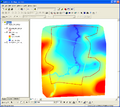
File:Tute M01 Arc 2d bc 1.png Tute M01: Arc, digitise 2d_bc layer step 1.(962 × 858 (145 KB)) - 11:38, 19 September 2011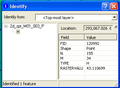
File:Tute M01 Arc Zpt Info2.png ArcMap: Module 1, 2d_zpt with null elevation field removed.(339 × 249 (8 KB)) - 10:46, 25 August 2011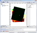
File:Tute M01 Saga Zpts All2.png Saga: Module 1, DEM and Zpts with attribute showing.(947 × 844 (86 KB)) - 12:06, 25 August 2011
File:Tute M01 VM ContourLines.png Create 0.5m contour lines of module 1 results.(411 × 460 (38 KB)) - 11:23, 17 August 2011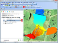
File:Tute M01 ContourLines Map.png Map showing 0.5m contours of module 1 results(963 × 724 (655 KB)) - 12:34, 17 August 2011
File:Tute M01 VM GridManager.png Vertical Mapper Grid Manager with tutorial module 1 results open.(400 × 212 (25 KB)) - 14:30, 16 August 2011


