QGIS SWMM Convert XPSWMM GIS Inlet Layers to SWMM
Introduction
This tool converts an XPSWMM GIS layer with 2D connectivity information for use with TUFLOW-SWMM. The tool operates on discharges computed from the equation: Q = coefficient * depthexponent.
This processing tool generates a GIS layer that can be used with the 'Read GIS SWMM Inlet Usage' command to link SWMM inlets to a TUFLOW 2D model.
To export the GIS layer required from XPSWMM or the XPSWMM Viewer:
- Right click on the nodes layer and choose 'Export to GIS'.
- Expand the tree folders 'Hydraulics Node\HDR Node Data'.
- Select 'Node 2D Inflow Capture Flag', 'Ground Elevation (Spill Crest)', '2D Inflow Capture Coefficient', and '2D Inflow Capture Exponent'.
- In the 'Custom Name' column, double click 'Ground Elevation (Spill Crest)' and update the name to 'Ground Elevation'. The parentheses can cause issues with some GIS software.
- Set the GIS filename. It is recommended to export to a MapInfo Interchange File (.mif).
- Click 'Export'.
The inlets require a name for each combination of coefficient and exponent that must be added to the GIS layer.
Once the layer is set up, run the tool and select the parameters for the appropriate fields. The ground elevation should be used for the 'Inlet elevation field.' The CRS should match the TUFLOW-SWMM project.
Note: To convert an entire XPSWMM model to TUFLOW-SWMM, see XPSWMM to TUFLOW-SWMM.
Usage
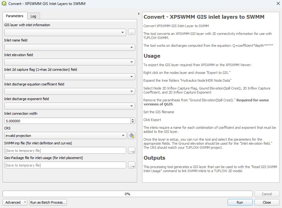
This tool, Convert - XPSWMM GIS inlet layers to SWMM, can be found in the QGIS processing toolbox panel under TUFLOW >> SWMM. To open the Processing Toolbox panel, navigate to 'Processing' in the menubar and select 'Toolbox'.

Parameters
- GIS layer with inlet information: XPSWMM GIS layer to be converted to TUFLOW-SWMM.
- Inlet name field: Name of the XPSWMM GIS layer's field that contains the names of the attributes. For example, a node layer, the inlet name field could be 'NodeName'.
- Inlet elevation field: Name of the XPSWMM GIS layer's field that contains the elevation data (GroundElevation).
- Inlet 2d capture flag (1=has 2d connection) field: Name of the XPSWMM GIS layer's field that determines whether the inlet is connected to the 2D domain (Node2DInflowCaptureFlag).
- Inlet discharge equation coefficient field: 'Coefficient' value from the equation above (2DInflowCaptureCoefficient).
- Inlet discharge exponent field: 'Exponent' value from the equation above (2DInflowCaptureExponent).
- Inlet connection width: The length used to assign the number of 2D cells associated with the 1D/2D connections.
- CRS: The CRS (Coordinate Reference System) for the TUFLOW-SWMM project. The tool will apply this CRS to the output files.
- SWMM inp file (for inlet definition and curves): Determines the location and filename of the output 'inlet definition and curves' data. This tool will save both a SWMM (.inp) and a GeoPackage (.gpkg) file to the specified output folder under the specified output name.
- GeoPackage file for inlet usage (for inlet placement): Determines the location and filename of the output inlet usage data. The tool will save this data in a GeoPackage (.gpkg) file.
Example
This video demonstrates how to convert an XPSWMM GIS inlet node layer to SWMM using the 'Convert - XPSWMM GIS inlet layers to SWMM' processing tool. In this example, the tool will produce an inlet usage GeoPackage file, an inlet curves GeoPackage file, and an inlet curves SWMM (.inp) file.
When loading the XPSWMM GIS inlet layer into QGIS, you may receive a message stating that there is no transform available between the CRS of the input (.mif or .shp) file and the CRS of the QGIS workspace. Ignore this message and close the pop up. This issue will be resolved by the processing tool as it will set the CRS of the output converted files.
| Up |
|---|
