Check Files 1d hydroprop
This file contains information on the hydraulic properties of the 1D channels.
Attributes of hydprop_check
| Attribute Name | Attribute Description |
|---|---|
| ID | The channel ID. |
| US_Node_ID | The upstream node ID for the channel. |
| DS_Node_ID | The downstream node ID for the channel. |
| Channel_Type | The channel type, see the TUFLOW Manual for a list of channel types. For example, an "S" type channel is a standard open channel, an "R" type channel is a rectangular culvert. |
| Manning_n | The primary Manning's n value for the channel. If this varies across the channel, e.g. an open channel with cross-section, the Manning's n value at the lowest point is reported. For some new structures this is the Cd coefficient. |
| Elev_at_Top | The highest elevation in the channel, for an open channel, this is the high point in the cross-section. For a structure the average channel obvert is output (calculated by adding the pipe height to the upstream and downstream invert levels and taking the average). Note that the water level can rise above this. See the ECF command Depth Limit Factor == in the TUFLOW Manual for more information on this. |
| Depth | The depth of the channel at the top elevation (see above). |
| Flow_Width | The flow width at the top of channel. |
| Storage_Width | The storage width at the top of the channel. |
| Flow_Area | The flow area at the top of the channel. |
| Conveyance | The conveyance value at the top of the channel. This is -1 for some structure channels. |
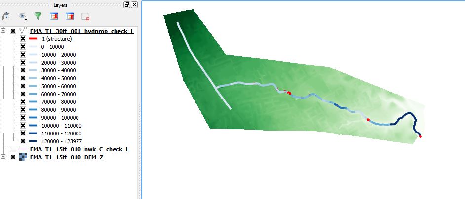
The hydraulic properties at the top of the channel can be very useful to map to ensure there are no sudden changes in channel geometry or input data that can stability issues. An example of mapping the conveyance in GIS can be found here:
- Mapinfo thematically mapping of hydroprop check file
- QGIS (to be created)
- ArcMap (to be created)
The image below shows a hydroprop layer styled by the conveyance attribute.

| Up |
|---|