Difference between revisions of "QGIS SWMM BC Create Channel Endpoint 1D/2D Connections"
Jump to navigation
Jump to search
| (9 intermediate revisions by the same user not shown) | |||
| Line 1: | Line 1: | ||
== Introduction == | == Introduction == | ||
| − | This tool creates 1D/2D connections at the endpoints of SWMM channels. HX connections are created on the upstream end and SX connections are created on the downstream end. <br> | + | This tool creates 1D/2D connections at the endpoints of SWMM channels. HX connections are created on the upstream end, and SX connections are created on the downstream end. <br> |
'''Note:''' The positions of the HX and SX connections may not be completely accurate, so it is recommended for the user to check the output. | '''Note:''' The positions of the HX and SX connections may not be completely accurate, so it is recommended for the user to check the output. | ||
| Line 14: | Line 14: | ||
<ol> | <ol> | ||
<li>'''Input Conduits Layer:''' The conduits layer to which the 1D/2D connections will be made. | <li>'''Input Conduits Layer:''' The conduits layer to which the 1D/2D connections will be made. | ||
| − | <li>'''Selected features only:''' If channel(s) in the conduits layer have been selected using the 'Select Features' tool, this option will become available. If | + | <li>'''Selected features only:''' If channel(s) in the conduits layer have been selected using the 'Select Features' tool, this option will become available. If checked on, the tool will only create 1D/2D connections for the selected channel(s). |
| − | <li>'''Create connections at:''' Specifies whether the 1D/2D connections are made at the | + | <li>'''Create connections at:''' Specifies whether the 1D/2D connections are made at the 'Upstream end', 'Downstream end', or 'Both ends' of the channel(s) in the conduits layer. |
<li>'''Offset distance:''' Distance from the channel endpoint to the midpoint of the BC line. | <li>'''Offset distance:''' Distance from the channel endpoint to the midpoint of the BC line. | ||
<li>'''Length of BC lines:''' Length of BC lines. | <li>'''Length of BC lines:''' Length of BC lines. | ||
| − | <li>'''Set 2D cell elevation to 1D culvert invert at 1D/2D connection cells if needed:''' If | + | <li>'''Set 2D cell elevation to 1D culvert invert at 1D/2D connection cells if needed:''' If checked on, SX and HX boundaries will have the 'Flags' attribute set to 'Z'. This ensures that valid elevations occur at the 1D/2D interface. HX boundaries require 2D cell elevations at or above the 1D elevation, while SX boundaries require 2D cell elevations at or below the 1D elevation. |
<li>'''Output Layer:''' Determines the location and filename of the output file. It is recommended to name the output layer with the prefix '''2d_bc''' so TUFLOW styles can be automatically applied. | <li>'''Output Layer:''' Determines the location and filename of the output file. It is recommended to name the output layer with the prefix '''2d_bc''' so TUFLOW styles can be automatically applied. | ||
</ol> | </ol> | ||
| Line 27: | Line 27: | ||
== Example == | == Example == | ||
<br> | <br> | ||
| − | {{Video|name= | + | {{Video|name=Animation_BC_Create_Channel_Endpoint_1D2D_Connections_01d.mp4|width=1236}} |
<br> | <br> | ||
| − | Using the 'Selected Features Only': | + | Using the 'Selected Features Only' option: |
<br><br> | <br><br> | ||
| − | {{Video|name= | + | {{Video|name=Animation_BC_Create_Channel_Endpoint_1D2D_Connections_02c.mp4|width=1236}} |
| − | + | ||
| + | |||
{{Tips Navigation | {{Tips Navigation | ||
|uplink=[[TUFLOW_QGIS_Plugin#Usage| Back to TUFLOW QGIS Plugin Main Page]] | |uplink=[[TUFLOW_QGIS_Plugin#Usage| Back to TUFLOW QGIS Plugin Main Page]] | ||
}} | }} | ||
Latest revision as of 11:57, 3 May 2024
Introduction
This tool creates 1D/2D connections at the endpoints of SWMM channels. HX connections are created on the upstream end, and SX connections are created on the downstream end.
Note: The positions of the HX and SX connections may not be completely accurate, so it is recommended for the user to check the output.
Usage
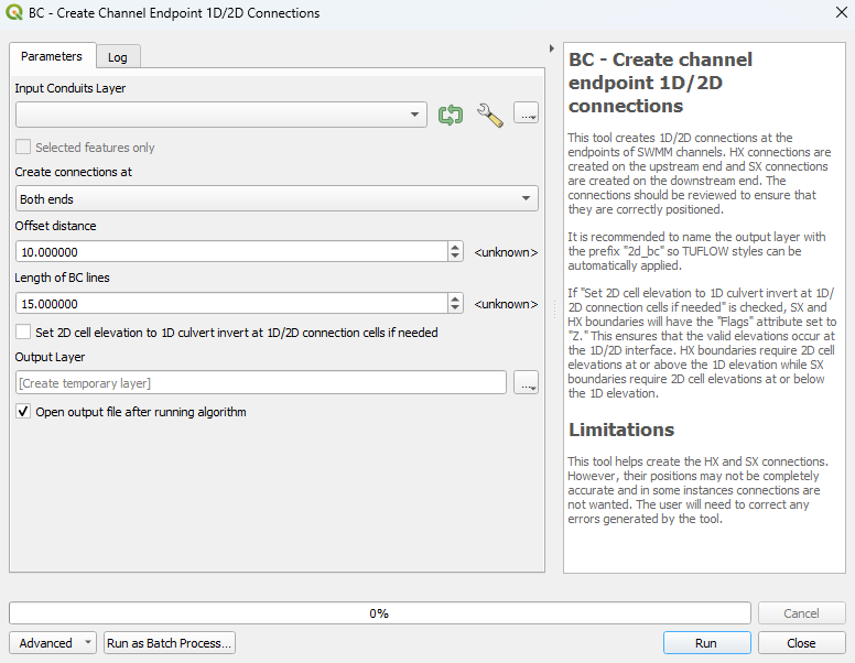
This tool, BC - Create channel endpoint 1D/2D connections, can be found in the QGIS processing toolbox panel under TUFLOW >> SWMM. To open the Processing Toolbox panel, navigate to 'Processing' in the menubar and select 'Toolbox'.

Parameters
- Input Conduits Layer: The conduits layer to which the 1D/2D connections will be made.
- Selected features only: If channel(s) in the conduits layer have been selected using the 'Select Features' tool, this option will become available. If checked on, the tool will only create 1D/2D connections for the selected channel(s).
- Create connections at: Specifies whether the 1D/2D connections are made at the 'Upstream end', 'Downstream end', or 'Both ends' of the channel(s) in the conduits layer.
- Offset distance: Distance from the channel endpoint to the midpoint of the BC line.
- Length of BC lines: Length of BC lines.
- Set 2D cell elevation to 1D culvert invert at 1D/2D connection cells if needed: If checked on, SX and HX boundaries will have the 'Flags' attribute set to 'Z'. This ensures that valid elevations occur at the 1D/2D interface. HX boundaries require 2D cell elevations at or above the 1D elevation, while SX boundaries require 2D cell elevations at or below the 1D elevation.
- Output Layer: Determines the location and filename of the output file. It is recommended to name the output layer with the prefix 2d_bc so TUFLOW styles can be automatically applied.
Example
Using the 'Selected Features Only' option:
| Up |
|---|
