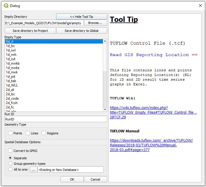
QGIS TUFLOW Import Empty
When working with GIS files in TUFLOW different model have inputs require different attributes. For example a initial water level layer (2d_iwl) layer only requires a single attribute (which is the initial water level value), whilst a 1d channel layer (1d_nwk) has a number of attributes including channel type, channel roughness, upstream and downstream elevation. These are created by running TUFLOW with the Write Empty GIS Files == <location> command, when working in QGIS this can also be completed with the configure/create TUFLOW project utility.
Running the Tool
The tool can be found in the TUFLOW Plugin toolbar, or via the QGIS menu Plugins >> TUFLOW >> Import Empty File

Empty Directory
The empty directory is the location that contains the template files. This is determined based on the directory set in the TUFLOW project tool. This can be changed by selecting the browse button. Please note that if using the browse button, it only sets if for this instance, if you want to change in the project please configure the project.
Empty Types
This control the empty file types to be imported. Multiple file types can be specified together. These file types are outlined in the TUFLOW manual.
Run ID
The Run ID is added to the filename of the created file. The final output name is made up of the empty type, run ID and geometry. When the utility is run with above inputs, (2d_code, run ID of M01_002 and Region type) the output filename will be 2d_code_M01_002_R.shp.
Geometry Type
The shapefile format only supports a single geometry type for each file. Each shapefile will contain one of points, lines and regions. Different datasets in TUFLOW will use different geometry types, for example the active and in-active model areas are defined by region (polygon) objects. In this section you can chose the geometry types to use, multiple types can be selected.
Note: Not all geometries are valid for all empty types. For example 2d_code layers are always regions and no point / line template is provided. Other datasets such as the 2D topography modifier (2d_zsh) format is valid for all three types.
With the settings as per the above, only a single input file is created and this is added to the top of the layer control as per the image below:
File:QgisTuflow ImportEmpty03.JPG
| Up |
|---|